You are here: Home > Network List > TA - USArray Transportable Network (new EarthScope stations) Stations List
> Station G59A Clarenceville, QC, USA > Earthquake Result Viewer
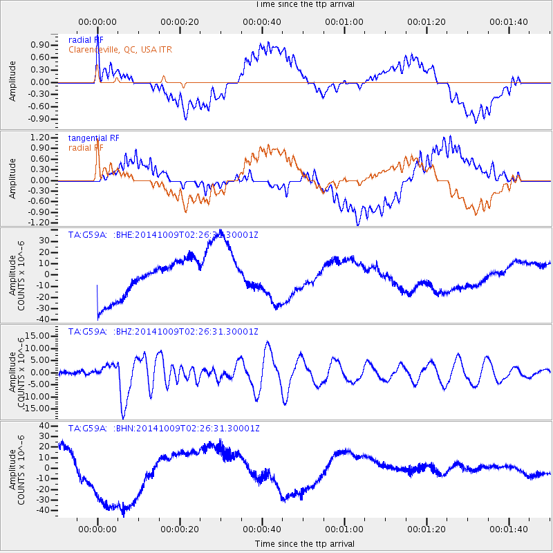
G59A Clarenceville, QC, USA - Earthquake Result Viewer
*The percent match for this event was below the threshold and hence no stack was calculated.
| Earthquake location: |
Southern East Pacific Rise |
| Earthquake latitude/longitude: |
-32.1/-110.8 |
| Earthquake time(UTC): |
2014/10/09 (282) 02:14:32 GMT |
| Earthquake Depth: |
16 km |
| Earthquake Magnitude: |
7.1 MWW, 6.8 MI |
| Earthquake Catalog/Contributor: |
NEIC PDE/NEIC COMCAT |
|
| Network: |
TA USArray Transportable Network (new EarthScope stations) |
| Station: |
G59A Clarenceville, QC, USA |
| Lat/Lon: |
45.08 N/73.18 W |
| Elevation: |
36 m |
|
| Distance: |
84.1 deg |
| Az: |
25.758 deg |
| Baz: |
211.366 deg |
| Ray Param: |
$rayparam |
*The percent match for this event was below the threshold and hence was not used in the summary stack. |
|
| Radial Match: |
26.383326 % |
| Radial Bump: |
400 |
| Transverse Match: |
16.868805 % |
| Transverse Bump: |
400 |
| SOD ConfigId: |
803114 |
| Insert Time: |
2014-10-23 02:47:12.895 +0000 |
| GWidth: |
2.5 |
| Max Bumps: |
400 |
| Tol: |
0.001 |
|
Signal To Noise
| Channel | StoN | STA | LTA |
| TA:G59A: :BHZ:20141009T02:26:31.30001Z | 6.0959687 | 2.5526597E-6 | 4.1874554E-7 |
| TA:G59A: :BHN:20141009T02:26:31.30001Z | 4.160337 | 5.2198175E-5 | 1.2546622E-5 |
| TA:G59A: :BHE:20141009T02:26:31.30001Z | 1.8480114 | 3.0416255E-5 | 1.6458911E-5 |
| Arrivals |
| Ps | |
| PpPs | |
| PsPs/PpSs | |


