You are here: Home > Network List > TA - USArray Transportable Network (new EarthScope stations) Stations List
> Station H17A Grant Village (NPS), Yellowstone Nt. Park, WY, USA > Earthquake Result Viewer
H17A Grant Village (NPS), Yellowstone Nt. Park, WY, USA - Earthquake Result Viewer

| Earthquake location: |
Southern East Pacific Rise |
| Earthquake latitude/longitude: |
-32.1/-110.8 |
| Earthquake time(UTC): |
2014/10/09 (282) 02:14:32 GMT |
| Earthquake Depth: |
16 km |
| Earthquake Magnitude: |
7.1 MWW, 6.8 MI |
| Earthquake Catalog/Contributor: |
NEIC PDE/NEIC COMCAT |
|
| Network: |
TA USArray Transportable Network (new EarthScope stations) |
| Station: |
H17A Grant Village (NPS), Yellowstone Nt. Park, WY, USA |
| Lat/Lon: |
44.40 N/110.58 W |
| Elevation: |
2400 m |
|
| Distance: |
76.1 deg |
| Az: |
0.15 deg |
| Baz: |
180.177 deg |
| Ray Param: |
0.051181022 |
| Estimated Moho Depth: |
12.0 km |
| Estimated Crust Vp/Vs: |
2.10 |
| Assumed Crust Vp: |
6.35 km/s |
| Estimated Crust Vs: |
3.027 km/s |
| Estimated Crust Poisson's Ratio: |
0.35 |
|
| Radial Match: |
84.53385 % |
| Radial Bump: |
400 |
| Transverse Match: |
92.22954 % |
| Transverse Bump: |
400 |
| SOD ConfigId: |
803114 |
| Insert Time: |
2014-10-23 02:47:31.253 +0000 |
| GWidth: |
2.5 |
| Max Bumps: |
400 |
| Tol: |
0.001 |
|
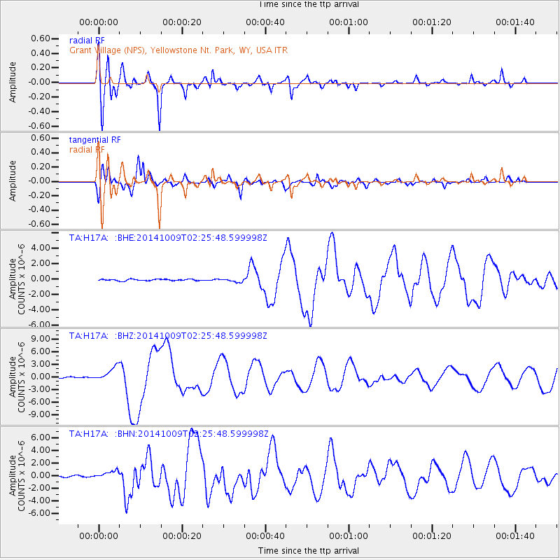
Signal To Noise
| Channel | StoN | STA | LTA |
| TA:H17A: :BHZ:20141009T02:25:48.599998Z | 14.393314 | 1.7677304E-6 | 1.2281608E-7 |
| TA:H17A: :BHN:20141009T02:25:48.599998Z | 5.531065 | 6.354614E-7 | 1.1488952E-7 |
| TA:H17A: :BHE:20141009T02:25:48.599998Z | 2.328329 | 2.202497E-7 | 9.4595606E-8 |
| Arrivals |
| Ps | 2.1 SECOND |
| PpPs | 5.7 SECOND |
| PsPs/PpSs | 7.8 SECOND |


