You are here: Home > Network List > TA - USArray Transportable Network (new EarthScope stations) Stations List
> Station H59A Cadyville, NY, USA > Earthquake Result Viewer
H59A Cadyville, NY, USA - Earthquake Result Viewer
| Earthquake location: |
Southern East Pacific Rise |
| Earthquake latitude/longitude: |
-32.1/-110.8 |
| Earthquake time(UTC): |
2014/10/09 (282) 02:14:32 GMT |
| Earthquake Depth: |
16 km |
| Earthquake Magnitude: |
7.1 MWW, 6.8 MI |
| Earthquake Catalog/Contributor: |
NEIC PDE/NEIC COMCAT |
|
| Network: |
TA USArray Transportable Network (new EarthScope stations) |
| Station: |
H59A Cadyville, NY, USA |
| Lat/Lon: |
44.65 N/73.69 W |
| Elevation: |
355 m |
|
| Distance: |
83.5 deg |
| Az: |
25.673 deg |
| Baz: |
210.999 deg |
| Ray Param: |
0.046113327 |
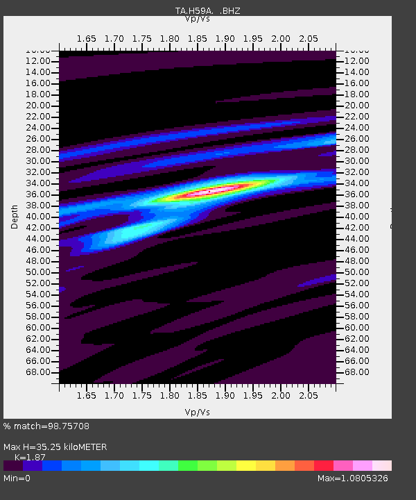
| Estimated Moho Depth: |
35.25 km |
| Estimated Crust Vp/Vs: |
1.87 |
| Assumed Crust Vp: |
6.419 km/s |
| Estimated Crust Vs: |
3.433 km/s |
| Estimated Crust Poisson's Ratio: |
0.30 |
|
| Radial Match: |
98.75708 % |
| Radial Bump: |
216 |
| Transverse Match: |
93.92071 % |
| Transverse Bump: |
366 |
| SOD ConfigId: |
803114 |
| Insert Time: |
2014-10-23 02:47:39.442 +0000 |
| GWidth: |
2.5 |
| Max Bumps: |
400 |
| Tol: |
0.001 |
|

Signal To Noise
| Channel | StoN | STA | LTA |
| TA:H59A: :BHZ:20141009T02:26:28.449973Z | 7.9794784 | 2.465568E-6 | 3.0898863E-7 |
| TA:H59A: :BHN:20141009T02:26:28.449973Z | 3.6357198 | 7.2510994E-7 | 1.9944055E-7 |
| TA:H59A: :BHE:20141009T02:26:28.449973Z | 1.4756435 | 4.0760037E-7 | 2.762187E-7 |
| Arrivals |
| Ps | 4.9 SECOND |
| PpPs | 15 SECOND |
| PsPs/PpSs | 20 SECOND |


