You are here: Home > Network List > TA - USArray Transportable Network (new EarthScope stations) Stations List
> Station H64A Troy, ME, USA > Earthquake Result Viewer
H64A Troy, ME, USA - Earthquake Result Viewer
| Earthquake location: |
Southern East Pacific Rise |
| Earthquake latitude/longitude: |
-32.1/-110.8 |
| Earthquake time(UTC): |
2014/10/09 (282) 02:14:32 GMT |
| Earthquake Depth: |
16 km |
| Earthquake Magnitude: |
7.1 MWW, 6.8 MI |
| Earthquake Catalog/Contributor: |
NEIC PDE/NEIC COMCAT |
|
| Network: |
TA USArray Transportable Network (new EarthScope stations) |
| Station: |
H64A Troy, ME, USA |
| Lat/Lon: |
44.64 N/69.22 W |
| Elevation: |
158 m |
|
| Distance: |
85.2 deg |
| Az: |
28.373 deg |
| Baz: |
214.394 deg |
| Ray Param: |
0.04488992 |
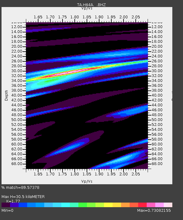
| Estimated Moho Depth: |
30.5 km |
| Estimated Crust Vp/Vs: |
1.77 |
| Assumed Crust Vp: |
6.419 km/s |
| Estimated Crust Vs: |
3.627 km/s |
| Estimated Crust Poisson's Ratio: |
0.27 |
|
| Radial Match: |
89.57378 % |
| Radial Bump: |
338 |
| Transverse Match: |
74.9994 % |
| Transverse Bump: |
400 |
| SOD ConfigId: |
803114 |
| Insert Time: |
2014-10-23 02:47:52.278 +0000 |
| GWidth: |
2.5 |
| Max Bumps: |
400 |
| Tol: |
0.001 |
|

Signal To Noise
| Channel | StoN | STA | LTA |
| TA:H64A: :BHZ:20141009T02:26:37.125022Z | 3.9929557 | 2.1557476E-6 | 5.398877E-7 |
| TA:H64A: :BHN:20141009T02:26:37.125022Z | 1.4223244 | 7.0183853E-7 | 4.9344476E-7 |
| TA:H64A: :BHE:20141009T02:26:37.125022Z | 1.2755401 | 5.2780626E-7 | 4.1379042E-7 |
| Arrivals |
| Ps | 3.7 SECOND |
| PpPs | 13 SECOND |
| PsPs/PpSs | 17 SECOND |


