You are here: Home > Network List > UW - Pacific Northwest Regional Seismic Network Stations List
> Station HOOD Mt Hood Meadows, OR CREST BB SMO > Earthquake Result Viewer
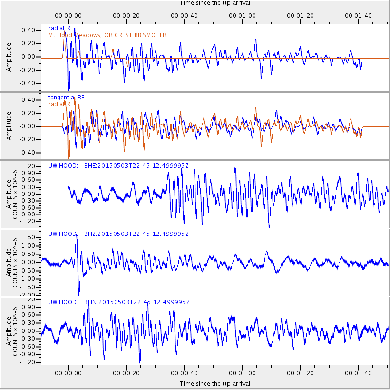
HOOD Mt Hood Meadows, OR CREST BB SMO - Earthquake Result Viewer
*The percent match for this event was below the threshold and hence no stack was calculated.
| Earthquake location: |
New Britain Region, P.N.G. |
| Earthquake latitude/longitude: |
-5.5/151.7 |
| Earthquake time(UTC): |
2015/05/03 (123) 22:32:42 GMT |
| Earthquake Depth: |
35 km |
| Earthquake Magnitude: |
5.6 MB |
| Earthquake Catalog/Contributor: |
NEIC PDE/NEIC COMCAT |
|
| Network: |
UW Pacific Northwest Regional Seismic Network |
| Station: |
HOOD Mt Hood Meadows, OR CREST BB SMO |
| Lat/Lon: |
45.32 N/121.65 W |
| Elevation: |
1520 m |
|
| Distance: |
91.5 deg |
| Az: |
44.792 deg |
| Baz: |
263.724 deg |
| Ray Param: |
$rayparam |
*The percent match for this event was below the threshold and hence was not used in the summary stack. |
|
| Radial Match: |
70.25295 % |
| Radial Bump: |
400 |
| Transverse Match: |
58.44018 % |
| Transverse Bump: |
400 |
| SOD ConfigId: |
7422571 |
| Insert Time: |
2019-04-18 15:32:34.332 +0000 |
| GWidth: |
2.5 |
| Max Bumps: |
400 |
| Tol: |
0.001 |
|
Signal To Noise
| Channel | StoN | STA | LTA |
| UW:HOOD: :BHZ:20150503T22:45:12.499995Z | 5.6798778 | 7.920262E-7 | 1.3944423E-7 |
| UW:HOOD: :BHN:20150503T22:45:12.499995Z | 1.0245708 | 1.9537572E-7 | 1.906903E-7 |
| UW:HOOD: :BHE:20150503T22:45:12.499995Z | 2.0994196 | 4.4681997E-7 | 2.1283023E-7 |
| Arrivals |
| Ps | |
| PpPs | |
| PsPs/PpSs | |


