You are here: Home > Network List > UW - Pacific Northwest Regional Seismic Network Stations List
> Station MRBL Marblemount, WA, USA > Earthquake Result Viewer
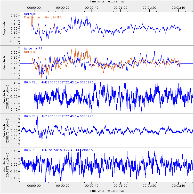
MRBL Marblemount, WA, USA - Earthquake Result Viewer
*The percent match for this event was below the threshold and hence no stack was calculated.
| Earthquake location: |
New Britain Region, P.N.G. |
| Earthquake latitude/longitude: |
-5.5/151.7 |
| Earthquake time(UTC): |
2015/05/03 (123) 22:32:42 GMT |
| Earthquake Depth: |
35 km |
| Earthquake Magnitude: |
5.6 MB |
| Earthquake Catalog/Contributor: |
NEIC PDE/NEIC COMCAT |
|
| Network: |
UW Pacific Northwest Regional Seismic Network |
| Station: |
MRBL Marblemount, WA, USA |
| Lat/Lon: |
48.52 N/121.48 W |
| Elevation: |
75 m |
|
| Distance: |
92.0 deg |
| Az: |
41.623 deg |
| Baz: |
263.944 deg |
| Ray Param: |
$rayparam |
*The percent match for this event was below the threshold and hence was not used in the summary stack. |
|
| Radial Match: |
63.4478 % |
| Radial Bump: |
400 |
| Transverse Match: |
60.009674 % |
| Transverse Bump: |
400 |
| SOD ConfigId: |
7422571 |
| Insert Time: |
2019-04-18 15:32:41.389 +0000 |
| GWidth: |
2.5 |
| Max Bumps: |
400 |
| Tol: |
0.001 |
|
Signal To Noise
| Channel | StoN | STA | LTA |
| UW:MRBL: :HHZ:20150503T22:45:14.608027Z | 3.3994253 | 4.2644822E-7 | 1.2544714E-7 |
| UW:MRBL: :HHN:20150503T22:45:14.608027Z | 1.1251615 | 1.2899763E-7 | 1.14648095E-7 |
| UW:MRBL: :HHE:20150503T22:45:14.608027Z | 0.9554768 | 1.2196007E-7 | 1.2764315E-7 |
| Arrivals |
| Ps | |
| PpPs | |
| PsPs/PpSs | |


