You are here: Home > Network List > TA - USArray Transportable Network (new EarthScope stations) Stations List
> Station J59A Piesco, NY, USA > Earthquake Result Viewer
J59A Piesco, NY, USA - Earthquake Result Viewer
| Earthquake location: |
Southern East Pacific Rise |
| Earthquake latitude/longitude: |
-32.1/-110.8 |
| Earthquake time(UTC): |
2014/10/09 (282) 02:14:32 GMT |
| Earthquake Depth: |
16 km |
| Earthquake Magnitude: |
7.1 MWW, 6.8 MI |
| Earthquake Catalog/Contributor: |
NEIC PDE/NEIC COMCAT |
|
| Network: |
TA USArray Transportable Network (new EarthScope stations) |
| Station: |
J59A Piesco, NY, USA |
| Lat/Lon: |
43.46 N/74.50 W |
| Elevation: |
541 m |
|
| Distance: |
82.2 deg |
| Az: |
25.772 deg |
| Baz: |
210.447 deg |
| Ray Param: |
0.047032062 |
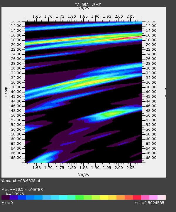
| Estimated Moho Depth: |
16.5 km |
| Estimated Crust Vp/Vs: |
2.10 |
| Assumed Crust Vp: |
6.419 km/s |
| Estimated Crust Vs: |
3.06 km/s |
| Estimated Crust Poisson's Ratio: |
0.35 |
|
| Radial Match: |
98.683846 % |
| Radial Bump: |
268 |
| Transverse Match: |
91.67044 % |
| Transverse Bump: |
400 |
| SOD ConfigId: |
803114 |
| Insert Time: |
2014-10-23 02:48:49.346 +0000 |
| GWidth: |
2.5 |
| Max Bumps: |
400 |
| Tol: |
0.001 |
|

Signal To Noise
| Channel | StoN | STA | LTA |
| TA:J59A: :BHZ:20141009T02:26:21.649985Z | 9.997759 | 2.2112074E-6 | 2.2117031E-7 |
| TA:J59A: :BHN:20141009T02:26:21.649985Z | 4.0346766 | 6.611279E-7 | 1.6386143E-7 |
| TA:J59A: :BHE:20141009T02:26:21.649985Z | 2.3519258 | 4.84244E-7 | 2.0589258E-7 |
| Arrivals |
| Ps | 2.9 SECOND |
| PpPs | 7.8 SECOND |
| PsPs/PpSs | 11 SECOND |


