You are here: Home > Network List > TA - USArray Transportable Network (new EarthScope stations) Stations List
> Station J60A Lant Hill Farm, Argyle, NY, USA > Earthquake Result Viewer
J60A Lant Hill Farm, Argyle, NY, USA - Earthquake Result Viewer
| Earthquake location: |
Southern East Pacific Rise |
| Earthquake latitude/longitude: |
-32.1/-110.8 |
| Earthquake time(UTC): |
2014/10/09 (282) 02:14:32 GMT |
| Earthquake Depth: |
16 km |
| Earthquake Magnitude: |
7.1 MWW, 6.8 MI |
| Earthquake Catalog/Contributor: |
NEIC PDE/NEIC COMCAT |
|
| Network: |
TA USArray Transportable Network (new EarthScope stations) |
| Station: |
J60A Lant Hill Farm, Argyle, NY, USA |
| Lat/Lon: |
43.24 N/73.42 W |
| Elevation: |
265 m |
|
| Distance: |
82.4 deg |
| Az: |
26.571 deg |
| Baz: |
211.295 deg |
| Ray Param: |
0.046882536 |
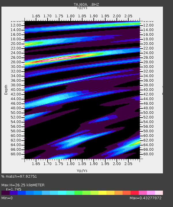
| Estimated Moho Depth: |
26.25 km |
| Estimated Crust Vp/Vs: |
1.75 |
| Assumed Crust Vp: |
6.419 km/s |
| Estimated Crust Vs: |
3.679 km/s |
| Estimated Crust Poisson's Ratio: |
0.26 |
|
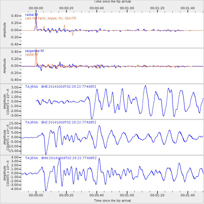
| Radial Match: |
97.92751 % |
| Radial Bump: |
263 |
| Transverse Match: |
97.065956 % |
| Transverse Bump: |
337 |
| SOD ConfigId: |
803114 |
| Insert Time: |
2014-10-23 02:48:50.510 +0000 |
| GWidth: |
2.5 |
| Max Bumps: |
400 |
| Tol: |
0.001 |
|
Signal To Noise
| Channel | StoN | STA | LTA |
| TA:J60A: :BHZ:20141009T02:26:22.774985Z | 8.262848 | 2.4580206E-6 | 2.9747864E-7 |
| TA:J60A: :BHN:20141009T02:26:22.774985Z | 5.243262 | 8.340952E-7 | 1.5907945E-7 |
| TA:J60A: :BHE:20141009T02:26:22.774985Z | 2.2753963 | 5.2862E-7 | 2.3231995E-7 |
| Arrivals |
| Ps | 3.1 SECOND |
| PpPs | 11 SECOND |
| PsPs/PpSs | 14 SECOND |


