You are here: Home > Network List > UW - Pacific Northwest Regional Seismic Network Stations List
> Station UMAT Pilot Rock, OR, USA > Earthquake Result Viewer
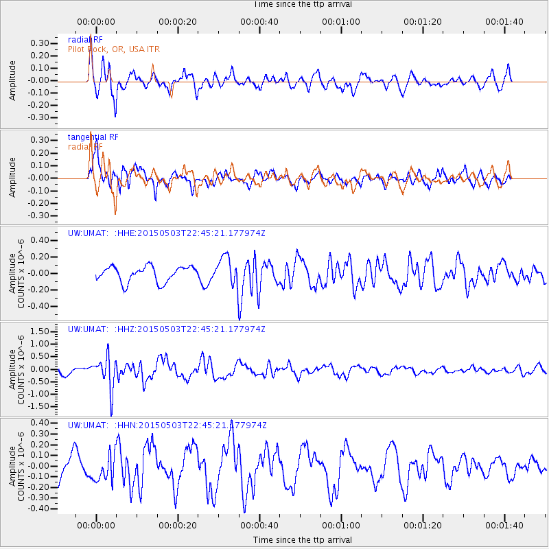
UMAT Pilot Rock, OR, USA - Earthquake Result Viewer
*The percent match for this event was below the threshold and hence no stack was calculated.
| Earthquake location: |
New Britain Region, P.N.G. |
| Earthquake latitude/longitude: |
-5.5/151.7 |
| Earthquake time(UTC): |
2015/05/03 (123) 22:32:42 GMT |
| Earthquake Depth: |
35 km |
| Earthquake Magnitude: |
5.6 MB |
| Earthquake Catalog/Contributor: |
NEIC PDE/NEIC COMCAT |
|
| Network: |
UW Pacific Northwest Regional Seismic Network |
| Station: |
UMAT Pilot Rock, OR, USA |
| Lat/Lon: |
45.29 N/118.96 W |
| Elevation: |
1318 m |
|
| Distance: |
93.4 deg |
| Az: |
45.0 deg |
| Baz: |
265.624 deg |
| Ray Param: |
$rayparam |
*The percent match for this event was below the threshold and hence was not used in the summary stack. |
|
| Radial Match: |
76.034874 % |
| Radial Bump: |
400 |
| Transverse Match: |
81.53998 % |
| Transverse Bump: |
400 |
| SOD ConfigId: |
7422571 |
| Insert Time: |
2019-04-18 15:32:48.190 +0000 |
| GWidth: |
2.5 |
| Max Bumps: |
400 |
| Tol: |
0.001 |
|
Signal To Noise
| Channel | StoN | STA | LTA |
| UW:UMAT: :HHZ:20150503T22:45:21.177974Z | 5.5544214 | 6.510265E-7 | 1.1720869E-7 |
| UW:UMAT: :HHN:20150503T22:45:21.177974Z | 1.1170769 | 1.2932506E-7 | 1.1577096E-7 |
| UW:UMAT: :HHE:20150503T22:45:21.177974Z | 2.664027 | 2.6011568E-7 | 9.7640026E-8 |
| Arrivals |
| Ps | |
| PpPs | |
| PsPs/PpSs | |


