You are here: Home > Network List > TA - USArray Transportable Network (new EarthScope stations) Stations List
> Station K59A Cooperstown, NY, USA > Earthquake Result Viewer
K59A Cooperstown, NY, USA - Earthquake Result Viewer
| Earthquake location: |
Southern East Pacific Rise |
| Earthquake latitude/longitude: |
-32.1/-110.8 |
| Earthquake time(UTC): |
2014/10/09 (282) 02:14:32 GMT |
| Earthquake Depth: |
16 km |
| Earthquake Magnitude: |
7.1 MWW, 6.8 MI |
| Earthquake Catalog/Contributor: |
NEIC PDE/NEIC COMCAT |
|
| Network: |
TA USArray Transportable Network (new EarthScope stations) |
| Station: |
K59A Cooperstown, NY, USA |
| Lat/Lon: |
42.78 N/74.85 W |
| Elevation: |
570 m |
|
| Distance: |
81.5 deg |
| Az: |
25.902 deg |
| Baz: |
210.228 deg |
| Ray Param: |
0.047539238 |
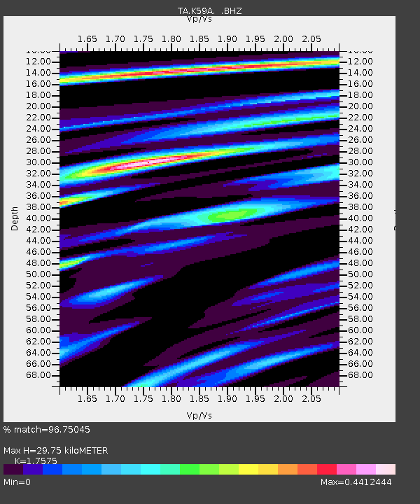
| Estimated Moho Depth: |
29.75 km |
| Estimated Crust Vp/Vs: |
1.76 |
| Assumed Crust Vp: |
6.419 km/s |
| Estimated Crust Vs: |
3.652 km/s |
| Estimated Crust Poisson's Ratio: |
0.26 |
|
| Radial Match: |
96.75045 % |
| Radial Bump: |
343 |
| Transverse Match: |
86.53377 % |
| Transverse Bump: |
400 |
| SOD ConfigId: |
803114 |
| Insert Time: |
2014-10-23 02:49:19.027 +0000 |
| GWidth: |
2.5 |
| Max Bumps: |
400 |
| Tol: |
0.001 |
|

Signal To Noise
| Channel | StoN | STA | LTA |
| TA:K59A: :BHZ:20141009T02:26:17.849998Z | 7.0350723 | 2.22762E-6 | 3.166449E-7 |
| TA:K59A: :BHN:20141009T02:26:17.849998Z | 4.902566 | 8.279034E-7 | 1.6887145E-7 |
| TA:K59A: :BHE:20141009T02:26:17.849998Z | 3.2491622 | 4.5336753E-7 | 1.3953368E-7 |
| Arrivals |
| Ps | 3.6 SECOND |
| PpPs | 12 SECOND |
| PsPs/PpSs | 16 SECOND |


