You are here: Home > Network List > TA - USArray Transportable Network (new EarthScope stations) Stations List
> Station L54A Sinclairville, NY, USA > Earthquake Result Viewer
L54A Sinclairville, NY, USA - Earthquake Result Viewer
| Earthquake location: |
Southern East Pacific Rise |
| Earthquake latitude/longitude: |
-32.1/-110.8 |
| Earthquake time(UTC): |
2014/10/09 (282) 02:14:32 GMT |
| Earthquake Depth: |
16 km |
| Earthquake Magnitude: |
7.1 MWW, 6.8 MI |
| Earthquake Catalog/Contributor: |
NEIC PDE/NEIC COMCAT |
|
| Network: |
TA USArray Transportable Network (new EarthScope stations) |
| Station: |
L54A Sinclairville, NY, USA |
| Lat/Lon: |
42.23 N/79.32 W |
| Elevation: |
432 m |
|
| Distance: |
79.4 deg |
| Az: |
23.222 deg |
| Baz: |
206.778 deg |
| Ray Param: |
0.048948407 |
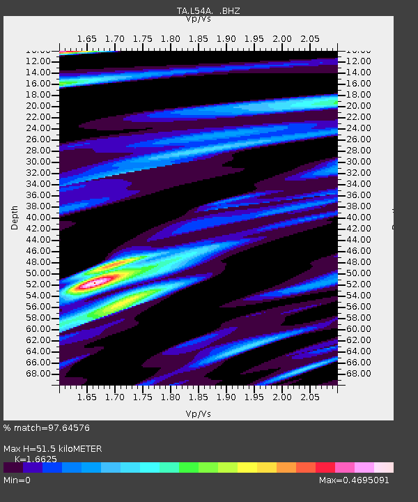
| Estimated Moho Depth: |
51.5 km |
| Estimated Crust Vp/Vs: |
1.66 |
| Assumed Crust Vp: |
6.419 km/s |
| Estimated Crust Vs: |
3.861 km/s |
| Estimated Crust Poisson's Ratio: |
0.22 |
|
| Radial Match: |
97.64576 % |
| Radial Bump: |
357 |
| Transverse Match: |
90.20507 % |
| Transverse Bump: |
400 |
| SOD ConfigId: |
803114 |
| Insert Time: |
2014-10-23 02:49:47.551 +0000 |
| GWidth: |
2.5 |
| Max Bumps: |
400 |
| Tol: |
0.001 |
|
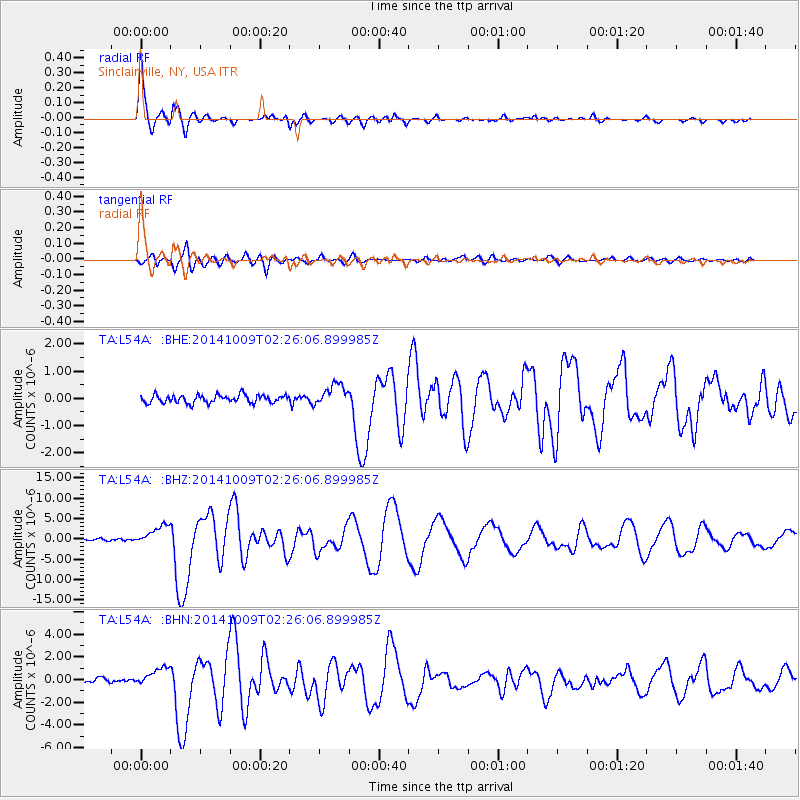
Signal To Noise
| Channel | StoN | STA | LTA |
| TA:L54A: :BHZ:20141009T02:26:06.899985Z | 10.735471 | 2.4561953E-6 | 2.2879252E-7 |
| TA:L54A: :BHN:20141009T02:26:06.899985Z | 3.7804189 | 8.071918E-7 | 2.1351913E-7 |
| TA:L54A: :BHE:20141009T02:26:06.899985Z | 2.7061841 | 3.9038238E-7 | 1.4425567E-7 |
| Arrivals |
| Ps | 5.5 SECOND |
| PpPs | 21 SECOND |
| PsPs/PpSs | 26 SECOND |


