You are here: Home > Network List > TA - USArray Transportable Network (new EarthScope stations) Stations List
> Station L55A Hinsdale, NY, USA > Earthquake Result Viewer
L55A Hinsdale, NY, USA - Earthquake Result Viewer

| Earthquake location: |
Southern East Pacific Rise |
| Earthquake latitude/longitude: |
-32.1/-110.8 |
| Earthquake time(UTC): |
2014/10/09 (282) 02:14:32 GMT |
| Earthquake Depth: |
16 km |
| Earthquake Magnitude: |
7.1 MWW, 6.8 MI |
| Earthquake Catalog/Contributor: |
NEIC PDE/NEIC COMCAT |
|
| Network: |
TA USArray Transportable Network (new EarthScope stations) |
| Station: |
L55A Hinsdale, NY, USA |
| Lat/Lon: |
42.18 N/78.44 W |
| Elevation: |
633 m |
|
| Distance: |
79.7 deg |
| Az: |
23.837 deg |
| Baz: |
207.479 deg |
| Ray Param: |
0.04877556 |
| Estimated Moho Depth: |
53.75 km |
| Estimated Crust Vp/Vs: |
1.62 |
| Assumed Crust Vp: |
6.419 km/s |
| Estimated Crust Vs: |
3.975 km/s |
| Estimated Crust Poisson's Ratio: |
0.19 |
|
| Radial Match: |
98.866455 % |
| Radial Bump: |
256 |
| Transverse Match: |
90.06431 % |
| Transverse Bump: |
400 |
| SOD ConfigId: |
803114 |
| Insert Time: |
2014-10-23 02:49:47.742 +0000 |
| GWidth: |
2.5 |
| Max Bumps: |
400 |
| Tol: |
0.001 |
|
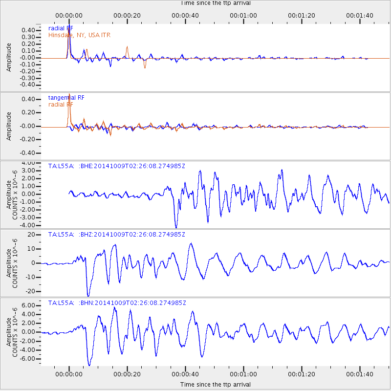
Signal To Noise
| Channel | StoN | STA | LTA |
| TA:L55A: :BHZ:20141009T02:26:08.274985Z | 8.939601 | 2.7112503E-6 | 3.032854E-7 |
| TA:L55A: :BHN:20141009T02:26:08.274985Z | 7.945507 | 9.4270587E-7 | 1.18646405E-7 |
| TA:L55A: :BHE:20141009T02:26:08.274985Z | 2.386757 | 5.088084E-7 | 2.1317982E-7 |
| Arrivals |
| Ps | 5.3 SECOND |
| PpPs | 21 SECOND |
| PsPs/PpSs | 27 SECOND |


