You are here: Home > Network List > TA - USArray Transportable Network (new EarthScope stations) Stations List
> Station L63A North Scituate, RI, USA > Earthquake Result Viewer
L63A North Scituate, RI, USA - Earthquake Result Viewer
| Earthquake location: |
Southern East Pacific Rise |
| Earthquake latitude/longitude: |
-32.1/-110.8 |
| Earthquake time(UTC): |
2014/10/09 (282) 02:14:32 GMT |
| Earthquake Depth: |
16 km |
| Earthquake Magnitude: |
7.1 MWW, 6.8 MI |
| Earthquake Catalog/Contributor: |
NEIC PDE/NEIC COMCAT |
|
| Network: |
TA USArray Transportable Network (new EarthScope stations) |
| Station: |
L63A North Scituate, RI, USA |
| Lat/Lon: |
41.86 N/71.61 W |
| Elevation: |
109 m |
|
| Distance: |
82.0 deg |
| Az: |
28.455 deg |
| Baz: |
212.771 deg |
| Ray Param: |
0.047202032 |
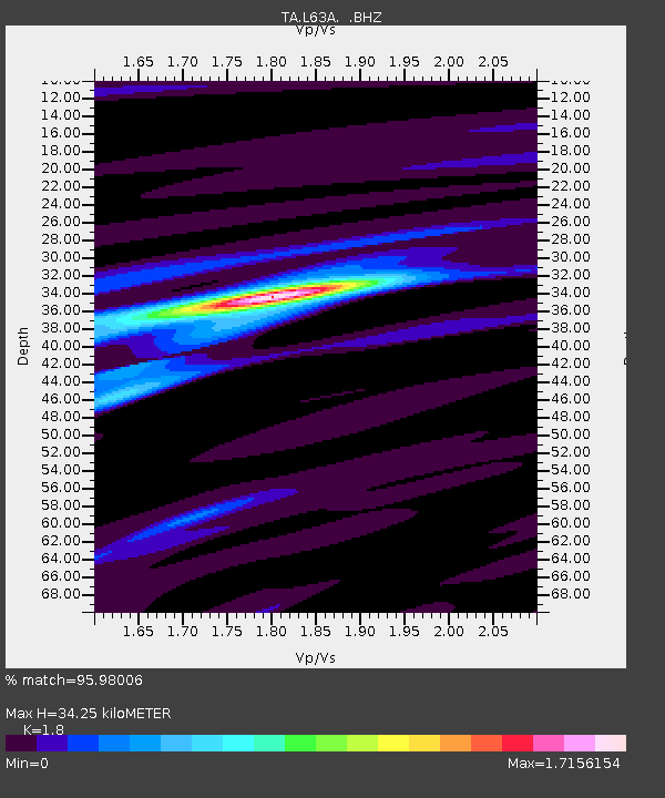
| Estimated Moho Depth: |
34.25 km |
| Estimated Crust Vp/Vs: |
1.80 |
| Assumed Crust Vp: |
6.472 km/s |
| Estimated Crust Vs: |
3.595 km/s |
| Estimated Crust Poisson's Ratio: |
0.28 |
|
| Radial Match: |
95.98006 % |
| Radial Bump: |
262 |
| Transverse Match: |
90.727264 % |
| Transverse Bump: |
400 |
| SOD ConfigId: |
803114 |
| Insert Time: |
2014-10-23 02:50:12.713 +0000 |
| GWidth: |
2.5 |
| Max Bumps: |
400 |
| Tol: |
0.001 |
|

Signal To Noise
| Channel | StoN | STA | LTA |
| TA:L63A: :BHZ:20141009T02:26:20.375022Z | 5.5191355 | 2.3738864E-6 | 4.3011926E-7 |
| TA:L63A: :BHN:20141009T02:26:20.375022Z | 2.8663783 | 8.002704E-7 | 2.791922E-7 |
| TA:L63A: :BHE:20141009T02:26:20.375022Z | 2.113805 | 6.194227E-7 | 2.930368E-7 |
| Arrivals |
| Ps | 4.3 SECOND |
| PpPs | 14 SECOND |
| PsPs/PpSs | 19 SECOND |


