You are here: Home > Network List > TA - USArray Transportable Network (new EarthScope stations) Stations List
> Station M57A Sunshine Farm, Cogan Station, PA, USA > Earthquake Result Viewer
M57A Sunshine Farm, Cogan Station, PA, USA - Earthquake Result Viewer
| Earthquake location: |
Southern East Pacific Rise |
| Earthquake latitude/longitude: |
-32.1/-110.8 |
| Earthquake time(UTC): |
2014/10/09 (282) 02:14:32 GMT |
| Earthquake Depth: |
16 km |
| Earthquake Magnitude: |
7.1 MWW, 6.8 MI |
| Earthquake Catalog/Contributor: |
NEIC PDE/NEIC COMCAT |
|
| Network: |
TA USArray Transportable Network (new EarthScope stations) |
| Station: |
M57A Sunshine Farm, Cogan Station, PA, USA |
| Lat/Lon: |
41.34 N/77.13 W |
| Elevation: |
319 m |
|
| Distance: |
79.4 deg |
| Az: |
25.12 deg |
| Baz: |
208.58 deg |
| Ray Param: |
0.048971526 |
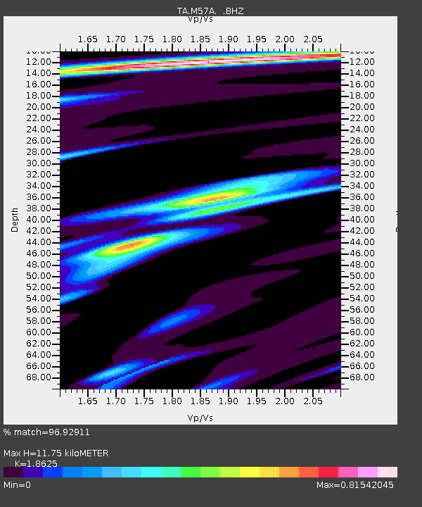
| Estimated Moho Depth: |
11.75 km |
| Estimated Crust Vp/Vs: |
1.86 |
| Assumed Crust Vp: |
6.121 km/s |
| Estimated Crust Vs: |
3.286 km/s |
| Estimated Crust Poisson's Ratio: |
0.30 |
|
| Radial Match: |
96.92911 % |
| Radial Bump: |
321 |
| Transverse Match: |
91.45519 % |
| Transverse Bump: |
400 |
| SOD ConfigId: |
803114 |
| Insert Time: |
2014-10-23 02:50:36.724 +0000 |
| GWidth: |
2.5 |
| Max Bumps: |
400 |
| Tol: |
0.001 |
|
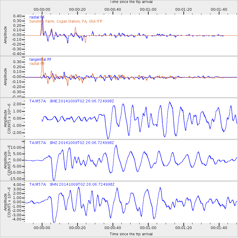
Signal To Noise
| Channel | StoN | STA | LTA |
| TA:M57A: :BHZ:20141009T02:26:06.724998Z | 12.247573 | 2.1706603E-6 | 1.7723187E-7 |
| TA:M57A: :BHN:20141009T02:26:06.724998Z | 4.405032 | 7.477397E-7 | 1.697467E-7 |
| TA:M57A: :BHE:20141009T02:26:06.724998Z | 1.9391057 | 4.1780487E-7 | 2.1546266E-7 |
| Arrivals |
| Ps | 1.7 SECOND |
| PpPs | 5.4 SECOND |
| PsPs/PpSs | 7.1 SECOND |


