You are here: Home > Network List > TA - USArray Transportable Network (new EarthScope stations) Stations List
> Station M60A Port Jervis, NY, USA > Earthquake Result Viewer
M60A Port Jervis, NY, USA - Earthquake Result Viewer
| Earthquake location: |
Southern East Pacific Rise |
| Earthquake latitude/longitude: |
-32.1/-110.8 |
| Earthquake time(UTC): |
2014/10/09 (282) 02:14:32 GMT |
| Earthquake Depth: |
16 km |
| Earthquake Magnitude: |
7.1 MWW, 6.8 MI |
| Earthquake Catalog/Contributor: |
NEIC PDE/NEIC COMCAT |
|
| Network: |
TA USArray Transportable Network (new EarthScope stations) |
| Station: |
M60A Port Jervis, NY, USA |
| Lat/Lon: |
41.33 N/74.62 W |
| Elevation: |
292 m |
|
| Distance: |
80.3 deg |
| Az: |
26.791 deg |
| Baz: |
210.521 deg |
| Ray Param: |
0.048341647 |
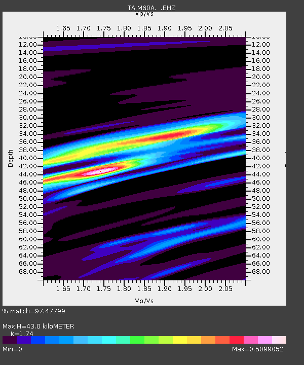
| Estimated Moho Depth: |
43.0 km |
| Estimated Crust Vp/Vs: |
1.74 |
| Assumed Crust Vp: |
6.283 km/s |
| Estimated Crust Vs: |
3.611 km/s |
| Estimated Crust Poisson's Ratio: |
0.25 |
|
| Radial Match: |
97.47799 % |
| Radial Bump: |
281 |
| Transverse Match: |
82.11129 % |
| Transverse Bump: |
400 |
| SOD ConfigId: |
803114 |
| Insert Time: |
2014-10-23 02:50:42.598 +0000 |
| GWidth: |
2.5 |
| Max Bumps: |
400 |
| Tol: |
0.001 |
|

Signal To Noise
| Channel | StoN | STA | LTA |
| TA:M60A: :BHZ:20141009T02:26:11.67501Z | 8.627147 | 2.0251732E-6 | 2.3474426E-7 |
| TA:M60A: :BHN:20141009T02:26:11.67501Z | 3.846313 | 6.728207E-7 | 1.7492616E-7 |
| TA:M60A: :BHE:20141009T02:26:11.67501Z | 2.2864707 | 3.7203705E-7 | 1.6271237E-7 |
| Arrivals |
| Ps | 5.2 SECOND |
| PpPs | 18 SECOND |
| PsPs/PpSs | 23 SECOND |


