You are here: Home > Network List > TA - USArray Transportable Network (new EarthScope stations) Stations List
> Station N54A Moraine State Park, Portersville, PA, USA > Earthquake Result Viewer
N54A Moraine State Park, Portersville, PA, USA - Earthquake Result Viewer
| Earthquake location: |
Southern East Pacific Rise |
| Earthquake latitude/longitude: |
-32.1/-110.8 |
| Earthquake time(UTC): |
2014/10/09 (282) 02:14:32 GMT |
| Earthquake Depth: |
16 km |
| Earthquake Magnitude: |
7.1 MWW, 6.8 MI |
| Earthquake Catalog/Contributor: |
NEIC PDE/NEIC COMCAT |
|
| Network: |
TA USArray Transportable Network (new EarthScope stations) |
| Station: |
N54A Moraine State Park, Portersville, PA, USA |
| Lat/Lon: |
40.96 N/79.99 W |
| Elevation: |
408 m |
|
| Distance: |
78.1 deg |
| Az: |
23.342 deg |
| Baz: |
206.357 deg |
| Ray Param: |
0.04987638 |
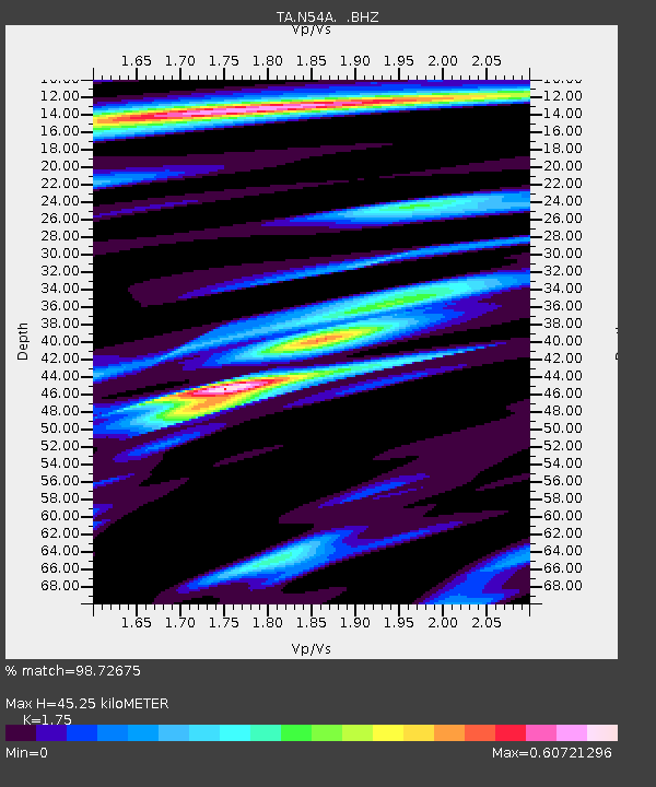
| Estimated Moho Depth: |
45.25 km |
| Estimated Crust Vp/Vs: |
1.75 |
| Assumed Crust Vp: |
6.121 km/s |
| Estimated Crust Vs: |
3.497 km/s |
| Estimated Crust Poisson's Ratio: |
0.26 |
|
| Radial Match: |
98.72675 % |
| Radial Bump: |
273 |
| Transverse Match: |
93.57167 % |
| Transverse Bump: |
400 |
| SOD ConfigId: |
803114 |
| Insert Time: |
2014-10-23 02:51:13.242 +0000 |
| GWidth: |
2.5 |
| Max Bumps: |
400 |
| Tol: |
0.001 |
|
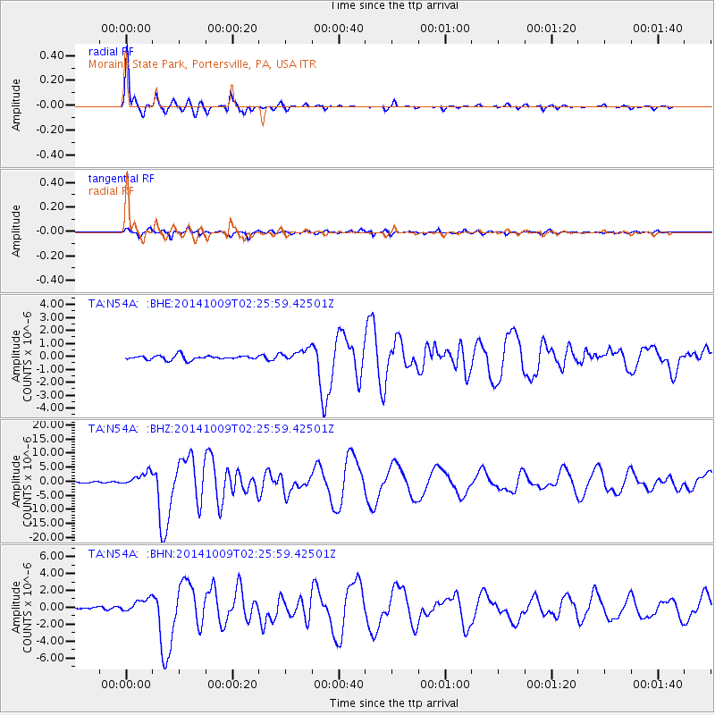
Signal To Noise
| Channel | StoN | STA | LTA |
| TA:N54A: :BHZ:20141009T02:25:59.42501Z | 7.3365126 | 2.4874778E-6 | 3.3905454E-7 |
| TA:N54A: :BHN:20141009T02:25:59.42501Z | 4.996036 | 8.210981E-7 | 1.6434991E-7 |
| TA:N54A: :BHE:20141009T02:25:59.42501Z | 2.8172805 | 4.721698E-7 | 1.6759772E-7 |
| Arrivals |
| Ps | 5.7 SECOND |
| PpPs | 20 SECOND |
| PsPs/PpSs | 25 SECOND |


