You are here: Home > Network List > IU - Global Seismograph Network (GSN - IRIS/USGS) Stations List
> Station GRFO Grafenberg, Germany > Earthquake Result Viewer
GRFO Grafenberg, Germany - Earthquake Result Viewer

| Earthquake location: |
Southern Sumatra, Indonesia |
| Earthquake latitude/longitude: |
-2.4/104.0 |
| Earthquake time(UTC): |
2004/07/25 (207) 14:35:19 GMT |
| Earthquake Depth: |
582 km |
| Earthquake Magnitude: |
6.8 MB, 7.3 MW, 7.3 MW |
| Earthquake Catalog/Contributor: |
WHDF/NEIC |
|
| Network: |
IU Global Seismograph Network (GSN - IRIS/USGS) |
| Station: |
GRFO Grafenberg, Germany |
| Lat/Lon: |
49.69 N/11.22 E |
| Elevation: |
425 m |
|
| Distance: |
93.6 deg |
| Az: |
319.461 deg |
| Baz: |
89.468 deg |
| Ray Param: |
0.04068533 |
| Estimated Moho Depth: |
30.25 km |
| Estimated Crust Vp/Vs: |
1.76 |
| Assumed Crust Vp: |
6.182 km/s |
| Estimated Crust Vs: |
3.503 km/s |
| Estimated Crust Poisson's Ratio: |
0.26 |
|
| Radial Match: |
94.6446 % |
| Radial Bump: |
387 |
| Transverse Match: |
80.04687 % |
| Transverse Bump: |
400 |
| SOD ConfigId: |
2459 |
| Insert Time: |
2010-03-02 02:08:59.413 +0000 |
| GWidth: |
2.5 |
| Max Bumps: |
400 |
| Tol: |
0.001 |
|
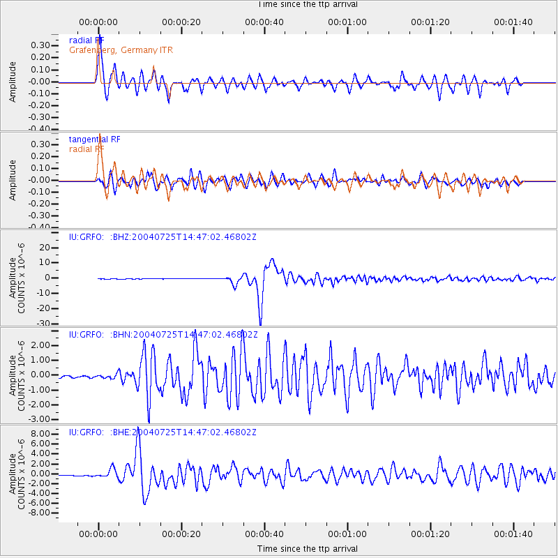
Signal To Noise
| Channel | StoN | STA | LTA |
| IU:GRFO: :BHN:20040725T14:47:02.46802Z | 2.0347764 | 1.5096484E-7 | 7.419235E-8 |
| IU:GRFO: :BHE:20040725T14:47:02.46802Z | 7.905161 | 9.4378447E-7 | 1.193884E-7 |
| IU:GRFO: :BHZ:20040725T14:47:02.46802Z | 22.327486 | 2.6864714E-6 | 1.2032127E-7 |
| Arrivals |
| Ps | 3.8 SECOND |
| PpPs | 13 SECOND |
| PsPs/PpSs | 17 SECOND |


