You are here: Home > Network List > TA - USArray Transportable Network (new EarthScope stations) Stations List
> Station O56A Blue Knob State Park, Imler, PA, USA > Earthquake Result Viewer
O56A Blue Knob State Park, Imler, PA, USA - Earthquake Result Viewer
| Earthquake location: |
Southern East Pacific Rise |
| Earthquake latitude/longitude: |
-32.1/-110.8 |
| Earthquake time(UTC): |
2014/10/09 (282) 02:14:32 GMT |
| Earthquake Depth: |
16 km |
| Earthquake Magnitude: |
7.1 MWW, 6.8 MI |
| Earthquake Catalog/Contributor: |
NEIC PDE/NEIC COMCAT |
|
| Network: |
TA USArray Transportable Network (new EarthScope stations) |
| Station: |
O56A Blue Knob State Park, Imler, PA, USA |
| Lat/Lon: |
40.27 N/78.57 W |
| Elevation: |
684 m |
|
| Distance: |
78.0 deg |
| Az: |
24.649 deg |
| Baz: |
207.551 deg |
| Ray Param: |
0.049962476 |
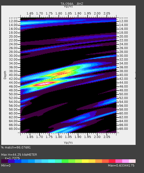
| Estimated Moho Depth: |
44.25 km |
| Estimated Crust Vp/Vs: |
1.73 |
| Assumed Crust Vp: |
6.121 km/s |
| Estimated Crust Vs: |
3.543 km/s |
| Estimated Crust Poisson's Ratio: |
0.25 |
|
| Radial Match: |
98.07691 % |
| Radial Bump: |
274 |
| Transverse Match: |
92.437355 % |
| Transverse Bump: |
400 |
| SOD ConfigId: |
803114 |
| Insert Time: |
2014-10-23 02:51:54.249 +0000 |
| GWidth: |
2.5 |
| Max Bumps: |
400 |
| Tol: |
0.001 |
|
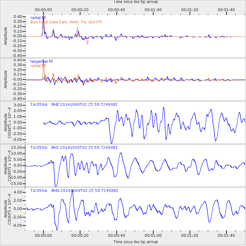
Signal To Noise
| Channel | StoN | STA | LTA |
| TA:O56A: :BHZ:20141009T02:25:58.724998Z | 10.279553 | 2.1927872E-6 | 2.133154E-7 |
| TA:O56A: :BHN:20141009T02:25:58.724998Z | 3.503877 | 6.474996E-7 | 1.8479518E-7 |
| TA:O56A: :BHE:20141009T02:25:58.724998Z | 2.4270334 | 4.6313662E-7 | 1.9082415E-7 |
| Arrivals |
| Ps | 5.4 SECOND |
| PpPs | 19 SECOND |
| PsPs/PpSs | 25 SECOND |


