You are here: Home > Network List > TA - USArray Transportable Network (new EarthScope stations) Stations List
> Station O58A Lewisberry, PA, USA > Earthquake Result Viewer
O58A Lewisberry, PA, USA - Earthquake Result Viewer
| Earthquake location: |
Southern East Pacific Rise |
| Earthquake latitude/longitude: |
-32.1/-110.8 |
| Earthquake time(UTC): |
2014/10/09 (282) 02:14:32 GMT |
| Earthquake Depth: |
16 km |
| Earthquake Magnitude: |
7.1 MWW, 6.8 MI |
| Earthquake Catalog/Contributor: |
NEIC PDE/NEIC COMCAT |
|
| Network: |
TA USArray Transportable Network (new EarthScope stations) |
| Station: |
O58A Lewisberry, PA, USA |
| Lat/Lon: |
40.12 N/76.92 W |
| Elevation: |
321 m |
|
| Distance: |
78.4 deg |
| Az: |
25.853 deg |
| Baz: |
208.854 deg |
| Ray Param: |
0.04964435 |
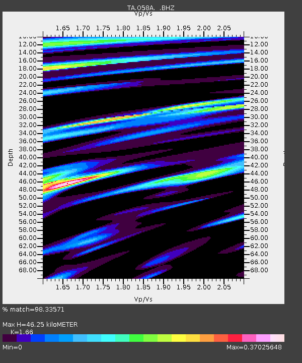
| Estimated Moho Depth: |
46.25 km |
| Estimated Crust Vp/Vs: |
1.66 |
| Assumed Crust Vp: |
6.121 km/s |
| Estimated Crust Vs: |
3.687 km/s |
| Estimated Crust Poisson's Ratio: |
0.22 |
|
| Radial Match: |
98.33571 % |
| Radial Bump: |
273 |
| Transverse Match: |
89.75444 % |
| Transverse Bump: |
400 |
| SOD ConfigId: |
803114 |
| Insert Time: |
2014-10-23 02:51:58.390 +0000 |
| GWidth: |
2.5 |
| Max Bumps: |
400 |
| Tol: |
0.001 |
|
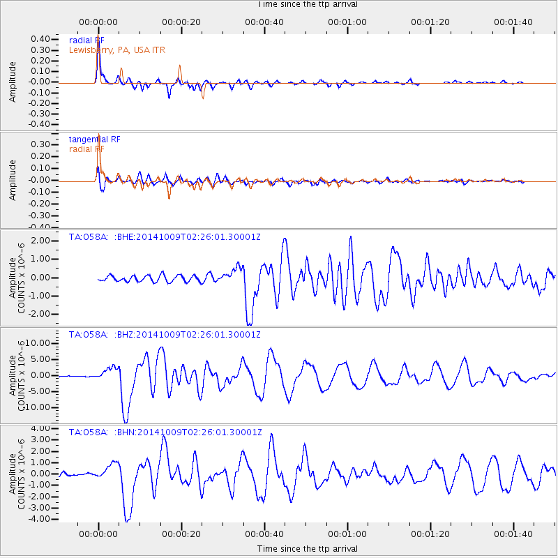
Signal To Noise
| Channel | StoN | STA | LTA |
| TA:O58A: :BHZ:20141009T02:26:01.30001Z | 12.451156 | 2.082257E-6 | 1.6723403E-7 |
| TA:O58A: :BHN:20141009T02:26:01.30001Z | 6.1943045 | 7.325451E-7 | 1.1826108E-7 |
| TA:O58A: :BHE:20141009T02:26:01.30001Z | 2.674548 | 4.3851873E-7 | 1.6395994E-7 |
| Arrivals |
| Ps | 5.1 SECOND |
| PpPs | 20 SECOND |
| PsPs/PpSs | 25 SECOND |


