You are here: Home > Network List > TA - USArray Transportable Network (new EarthScope stations) Stations List
> Station O61A Allentown, NJ, USA > Earthquake Result Viewer
O61A Allentown, NJ, USA - Earthquake Result Viewer
| Earthquake location: |
Southern East Pacific Rise |
| Earthquake latitude/longitude: |
-32.1/-110.8 |
| Earthquake time(UTC): |
2014/10/09 (282) 02:14:32 GMT |
| Earthquake Depth: |
16 km |
| Earthquake Magnitude: |
7.1 MWW, 6.8 MI |
| Earthquake Catalog/Contributor: |
NEIC PDE/NEIC COMCAT |
|
| Network: |
TA USArray Transportable Network (new EarthScope stations) |
| Station: |
O61A Allentown, NJ, USA |
| Lat/Lon: |
40.09 N/74.55 W |
| Elevation: |
38 m |
|
| Distance: |
79.3 deg |
| Az: |
27.476 deg |
| Baz: |
210.689 deg |
| Ray Param: |
0.04904829 |
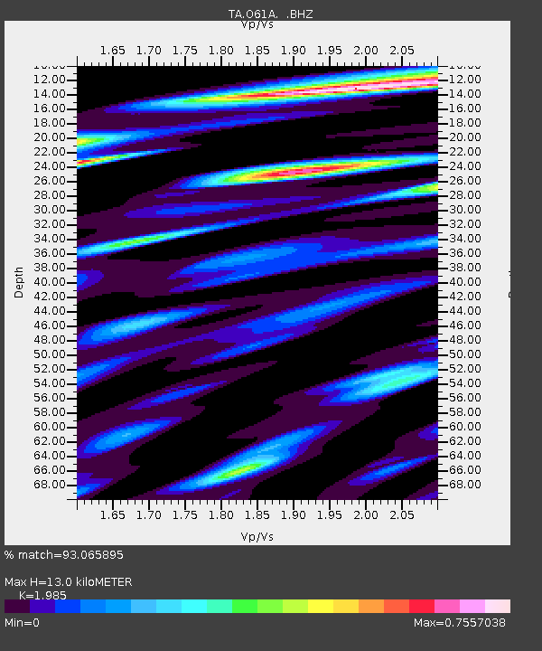
| Estimated Moho Depth: |
13.0 km |
| Estimated Crust Vp/Vs: |
1.99 |
| Assumed Crust Vp: |
6.283 km/s |
| Estimated Crust Vs: |
3.165 km/s |
| Estimated Crust Poisson's Ratio: |
0.33 |
|
| Radial Match: |
93.065895 % |
| Radial Bump: |
400 |
| Transverse Match: |
69.77069 % |
| Transverse Bump: |
400 |
| SOD ConfigId: |
803114 |
| Insert Time: |
2014-10-23 02:52:05.362 +0000 |
| GWidth: |
2.5 |
| Max Bumps: |
400 |
| Tol: |
0.001 |
|

Signal To Noise
| Channel | StoN | STA | LTA |
| TA:O61A: :BHZ:20141009T02:26:06.099998Z | 11.268529 | 2.3402997E-6 | 2.0768458E-7 |
| TA:O61A: :BHN:20141009T02:26:06.099998Z | 2.4560435 | 9.336863E-7 | 3.801587E-7 |
| TA:O61A: :BHE:20141009T02:26:06.099998Z | 1.477161 | 6.0497024E-7 | 4.0954927E-7 |
| Arrivals |
| Ps | 2.1 SECOND |
| PpPs | 6.0 SECOND |
| PsPs/PpSs | 8.1 SECOND |


