You are here: Home > Network List > TA - USArray Transportable Network (new EarthScope stations) Stations List
> Station P52A Corning, OH, USA > Earthquake Result Viewer
P52A Corning, OH, USA - Earthquake Result Viewer
| Earthquake location: |
Southern East Pacific Rise |
| Earthquake latitude/longitude: |
-32.1/-110.8 |
| Earthquake time(UTC): |
2014/10/09 (282) 02:14:32 GMT |
| Earthquake Depth: |
16 km |
| Earthquake Magnitude: |
7.1 MWW, 6.8 MI |
| Earthquake Catalog/Contributor: |
NEIC PDE/NEIC COMCAT |
|
| Network: |
TA USArray Transportable Network (new EarthScope stations) |
| Station: |
P52A Corning, OH, USA |
| Lat/Lon: |
39.63 N/82.13 W |
| Elevation: |
293 m |
|
| Distance: |
76.2 deg |
| Az: |
22.412 deg |
| Baz: |
204.768 deg |
| Ray Param: |
0.05116103 |
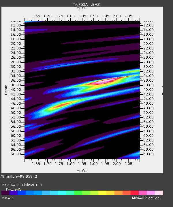
| Estimated Moho Depth: |
36.0 km |
| Estimated Crust Vp/Vs: |
1.95 |
| Assumed Crust Vp: |
6.232 km/s |
| Estimated Crust Vs: |
3.204 km/s |
| Estimated Crust Poisson's Ratio: |
0.32 |
|
| Radial Match: |
98.65942 % |
| Radial Bump: |
233 |
| Transverse Match: |
94.617905 % |
| Transverse Bump: |
336 |
| SOD ConfigId: |
803114 |
| Insert Time: |
2014-10-23 02:52:11.525 +0000 |
| GWidth: |
2.5 |
| Max Bumps: |
400 |
| Tol: |
0.001 |
|

Signal To Noise
| Channel | StoN | STA | LTA |
| TA:P52A: :BHZ:20141009T02:25:48.774985Z | 12.752655 | 2.2485283E-6 | 1.7631845E-7 |
| TA:P52A: :BHN:20141009T02:25:48.774985Z | 5.5765424 | 8.30114E-7 | 1.4885818E-7 |
| TA:P52A: :BHE:20141009T02:25:48.774985Z | 2.3068454 | 4.084401E-7 | 1.7705568E-7 |
| Arrivals |
| Ps | 5.6 SECOND |
| PpPs | 17 SECOND |
| PsPs/PpSs | 22 SECOND |


