You are here: Home > Network List > TA - USArray Transportable Network (new EarthScope stations) Stations List
> Station Q57A Strasburg, VA, USA > Earthquake Result Viewer
Q57A Strasburg, VA, USA - Earthquake Result Viewer
| Earthquake location: |
Southern East Pacific Rise |
| Earthquake latitude/longitude: |
-32.1/-110.8 |
| Earthquake time(UTC): |
2014/10/09 (282) 02:14:32 GMT |
| Earthquake Depth: |
16 km |
| Earthquake Magnitude: |
7.1 MWW, 6.8 MI |
| Earthquake Catalog/Contributor: |
NEIC PDE/NEIC COMCAT |
|
| Network: |
TA USArray Transportable Network (new EarthScope stations) |
| Station: |
Q57A Strasburg, VA, USA |
| Lat/Lon: |
39.04 N/78.41 W |
| Elevation: |
324 m |
|
| Distance: |
76.9 deg |
| Az: |
25.344 deg |
| Baz: |
207.801 deg |
| Ray Param: |
0.05066222 |
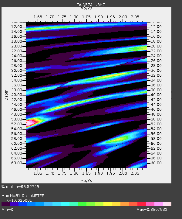
| Estimated Moho Depth: |
51.0 km |
| Estimated Crust Vp/Vs: |
1.60 |
| Assumed Crust Vp: |
6.159 km/s |
| Estimated Crust Vs: |
3.843 km/s |
| Estimated Crust Poisson's Ratio: |
0.18 |
|
| Radial Match: |
98.52749 % |
| Radial Bump: |
282 |
| Transverse Match: |
93.15858 % |
| Transverse Bump: |
400 |
| SOD ConfigId: |
803114 |
| Insert Time: |
2014-10-23 02:52:47.295 +0000 |
| GWidth: |
2.5 |
| Max Bumps: |
400 |
| Tol: |
0.001 |
|

Signal To Noise
| Channel | StoN | STA | LTA |
| TA:Q57A: :BHZ:20141009T02:25:52.949973Z | 13.226209 | 2.2662337E-6 | 1.7134417E-7 |
| TA:Q57A: :BHN:20141009T02:25:52.949973Z | 8.63429 | 8.265573E-7 | 9.572962E-8 |
| TA:Q57A: :BHE:20141009T02:25:52.949973Z | 2.9393594 | 4.2299698E-7 | 1.4390788E-7 |
| Arrivals |
| Ps | 5.1 SECOND |
| PpPs | 21 SECOND |
| PsPs/PpSs | 26 SECOND |


