You are here: Home > Network List > TA - USArray Transportable Network (new EarthScope stations) Stations List
> Station R54A Victor, WV, USA > Earthquake Result Viewer
R54A Victor, WV, USA - Earthquake Result Viewer
| Earthquake location: |
Southern East Pacific Rise |
| Earthquake latitude/longitude: |
-32.1/-110.8 |
| Earthquake time(UTC): |
2014/10/09 (282) 02:14:32 GMT |
| Earthquake Depth: |
16 km |
| Earthquake Magnitude: |
7.1 MWW, 6.8 MI |
| Earthquake Catalog/Contributor: |
NEIC PDE/NEIC COMCAT |
|
| Network: |
TA USArray Transportable Network (new EarthScope stations) |
| Station: |
R54A Victor, WV, USA |
| Lat/Lon: |
38.18 N/80.99 W |
| Elevation: |
512 m |
|
| Distance: |
75.2 deg |
| Az: |
23.883 deg |
| Baz: |
205.846 deg |
| Ray Param: |
0.051789246 |
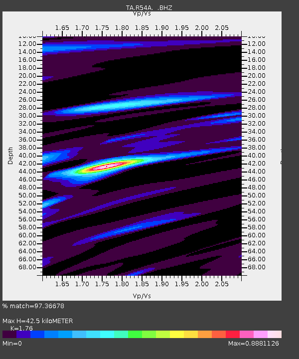
| Estimated Moho Depth: |
42.5 km |
| Estimated Crust Vp/Vs: |
1.76 |
| Assumed Crust Vp: |
6.207 km/s |
| Estimated Crust Vs: |
3.527 km/s |
| Estimated Crust Poisson's Ratio: |
0.26 |
|
| Radial Match: |
97.36678 % |
| Radial Bump: |
226 |
| Transverse Match: |
91.812935 % |
| Transverse Bump: |
390 |
| SOD ConfigId: |
803114 |
| Insert Time: |
2014-10-23 02:53:03.583 +0000 |
| GWidth: |
2.5 |
| Max Bumps: |
400 |
| Tol: |
0.001 |
|
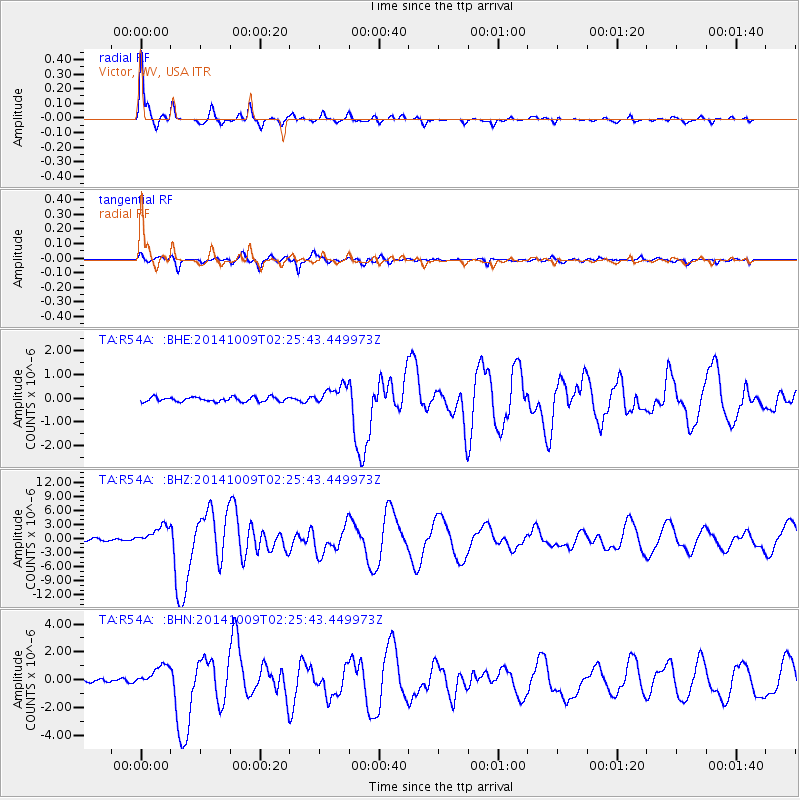
Signal To Noise
| Channel | StoN | STA | LTA |
| TA:R54A: :BHZ:20141009T02:25:43.449973Z | 10.792416 | 2.036854E-6 | 1.8873014E-7 |
| TA:R54A: :BHN:20141009T02:25:43.449973Z | 7.010744 | 7.4818877E-7 | 1.0672031E-7 |
| TA:R54A: :BHE:20141009T02:25:43.449973Z | 4.351305 | 4.1508676E-7 | 9.5393624E-8 |
| Arrivals |
| Ps | 5.4 SECOND |
| PpPs | 18 SECOND |
| PsPs/PpSs | 24 SECOND |


