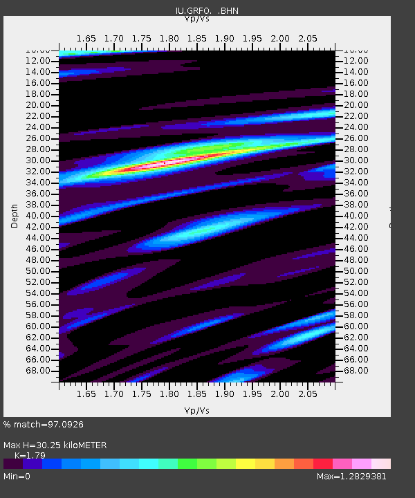
GRFO Grafenberg, Germany - Earthquake Result Viewer

Earthquake location: Off W Coast Of Northern Sumatra
Earthquake latitude/longitude: 2.8/96.0
Earthquake time(UTC): 2008/02/20 (051) 08:08:30 GMT
Earthquake Depth: 26 km
Earthquake Magnitude: 6.5 MB, 7.5 MS, 7.4 MW, 7.4 MW
Earthquake Catalog/Contributor: WHDF/NEIC
Network: IU Global Seismograph Network (GSN - IRIS/USGS)
Station: GRFO Grafenberg, Germany
Lat/Lon: 49.69 N/11.22 E
Elevation: 384 m
Distance: 84.5 deg
Az: 319.481 deg
Baz: 92.213 deg
Ray Param: 0.04541119
Estimated Moho Depth: 30.25 km
Estimated Crust Vp/Vs: 1.79
Assumed Crust Vp: 6.182 km/s
Estimated Crust Vs: 3.454 km/s
Estimated Crust Poisson's Ratio: 0.27
Radial Match: 97.0926 %
Radial Bump: 400
Transverse Match: 88.245384 %
Transverse Bump: 400
SOD ConfigId: 2564
Insert Time: 2010-03-02 02:10:53.965 +0000
GWidth: 2.5
Max Bumps: 400
Tol: 0.001

Signal To Noise

ChannelStoNSTALTA
IU:GRFO: :BHN:20080220T08:20:29.670024Z1.08660841.10604375E-71.0178863E-7
IU:GRFO: :BHE:20080220T08:20:29.670024Z2.66487624.8420327E-71.8169823E-7
IU:GRFO: :BHZ:20080220T08:20:29.670024Z6.19542551.1366747E-61.8347E-7
Arrivals
Ps4.0 SECOND
PpPs13 SECOND
PsPs/PpSs17 SECOND