You are here: Home > Network List > TA - USArray Transportable Network (new EarthScope stations) Stations List
> Station U60A Pendleton, NC, USA > Earthquake Result Viewer
U60A Pendleton, NC, USA - Earthquake Result Viewer
| Earthquake location: |
Southern East Pacific Rise |
| Earthquake latitude/longitude: |
-32.1/-110.8 |
| Earthquake time(UTC): |
2014/10/09 (282) 02:14:32 GMT |
| Earthquake Depth: |
16 km |
| Earthquake Magnitude: |
7.1 MWW, 6.8 MI |
| Earthquake Catalog/Contributor: |
NEIC PDE/NEIC COMCAT |
|
| Network: |
TA USArray Transportable Network (new EarthScope stations) |
| Station: |
U60A Pendleton, NC, USA |
| Lat/Lon: |
36.47 N/77.16 W |
| Elevation: |
8.0 m |
|
| Distance: |
75.1 deg |
| Az: |
27.499 deg |
| Baz: |
209.084 deg |
| Ray Param: |
0.051856924 |
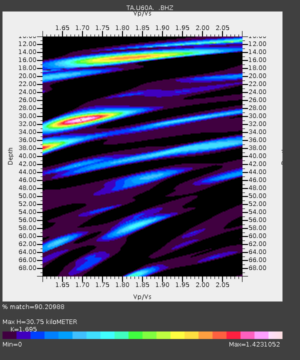
| Estimated Moho Depth: |
30.75 km |
| Estimated Crust Vp/Vs: |
1.70 |
| Assumed Crust Vp: |
6.565 km/s |
| Estimated Crust Vs: |
3.873 km/s |
| Estimated Crust Poisson's Ratio: |
0.23 |
|
| Radial Match: |
90.20988 % |
| Radial Bump: |
400 |
| Transverse Match: |
80.46026 % |
| Transverse Bump: |
400 |
| SOD ConfigId: |
803114 |
| Insert Time: |
2014-10-23 02:54:48.247 +0000 |
| GWidth: |
2.5 |
| Max Bumps: |
400 |
| Tol: |
0.001 |
|

Signal To Noise
| Channel | StoN | STA | LTA |
| TA:U60A: :BHZ:20141009T02:25:42.849998Z | 20.797012 | 2.3482135E-6 | 1.12911096E-7 |
| TA:U60A: :BHN:20141009T02:25:42.849998Z | 8.513039 | 9.906526E-7 | 1.1636885E-7 |
| TA:U60A: :BHE:20141009T02:25:42.849998Z | 3.8132484 | 5.188989E-7 | 1.3607792E-7 |
| Arrivals |
| Ps | 3.4 SECOND |
| PpPs | 12 SECOND |
| PsPs/PpSs | 16 SECOND |


