You are here: Home > Network List > TA - USArray Transportable Network (new EarthScope stations) Stations List
> Station U61A Possum Corner Farms, Belvidere, NC, USA > Earthquake Result Viewer
U61A Possum Corner Farms, Belvidere, NC, USA - Earthquake Result Viewer
| Earthquake location: |
Southern East Pacific Rise |
| Earthquake latitude/longitude: |
-32.1/-110.8 |
| Earthquake time(UTC): |
2014/10/09 (282) 02:14:32 GMT |
| Earthquake Depth: |
16 km |
| Earthquake Magnitude: |
7.1 MWW, 6.8 MI |
| Earthquake Catalog/Contributor: |
NEIC PDE/NEIC COMCAT |
|
| Network: |
TA USArray Transportable Network (new EarthScope stations) |
| Station: |
U61A Possum Corner Farms, Belvidere, NC, USA |
| Lat/Lon: |
36.33 N/76.45 W |
| Elevation: |
4.0 m |
|
| Distance: |
75.3 deg |
| Az: |
28.088 deg |
| Baz: |
209.656 deg |
| Ray Param: |
0.051752195 |
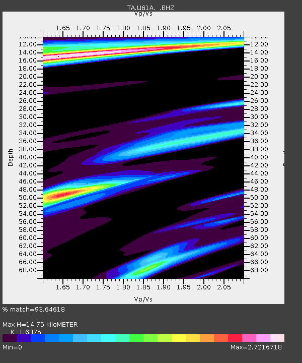
| Estimated Moho Depth: |
14.75 km |
| Estimated Crust Vp/Vs: |
1.64 |
| Assumed Crust Vp: |
6.565 km/s |
| Estimated Crust Vs: |
4.009 km/s |
| Estimated Crust Poisson's Ratio: |
0.20 |
|
| Radial Match: |
93.64618 % |
| Radial Bump: |
400 |
| Transverse Match: |
88.792915 % |
| Transverse Bump: |
400 |
| SOD ConfigId: |
803114 |
| Insert Time: |
2014-10-23 02:54:48.836 +0000 |
| GWidth: |
2.5 |
| Max Bumps: |
400 |
| Tol: |
0.001 |
|

Signal To Noise
| Channel | StoN | STA | LTA |
| TA:U61A: :BHZ:20141009T02:25:43.774985Z | 5.999703 | 2.1758106E-6 | 3.6265303E-7 |
| TA:U61A: :BHN:20141009T02:25:43.774985Z | 1.8209771 | 1.152359E-6 | 6.3282454E-7 |
| TA:U61A: :BHE:20141009T02:25:43.774985Z | 2.5711317 | 9.73858E-7 | 3.787663E-7 |
| Arrivals |
| Ps | 1.5 SECOND |
| PpPs | 5.7 SECOND |
| PsPs/PpSs | 7.2 SECOND |


