You are here: Home > Network List > TA - USArray Transportable Network (new EarthScope stations) Stations List
> Station V55A Taylorsville, NC, USA > Earthquake Result Viewer
V55A Taylorsville, NC, USA - Earthquake Result Viewer

| Earthquake location: |
Southern East Pacific Rise |
| Earthquake latitude/longitude: |
-32.1/-110.8 |
| Earthquake time(UTC): |
2014/10/09 (282) 02:14:32 GMT |
| Earthquake Depth: |
16 km |
| Earthquake Magnitude: |
7.1 MWW, 6.8 MI |
| Earthquake Catalog/Contributor: |
NEIC PDE/NEIC COMCAT |
|
| Network: |
TA USArray Transportable Network (new EarthScope stations) |
| Station: |
V55A Taylorsville, NC, USA |
| Lat/Lon: |
35.85 N/81.21 W |
| Elevation: |
306 m |
|
| Distance: |
73.1 deg |
| Az: |
24.77 deg |
| Baz: |
205.954 deg |
| Ray Param: |
0.05323269 |
| Estimated Moho Depth: |
44.75 km |
| Estimated Crust Vp/Vs: |
1.70 |
| Assumed Crust Vp: |
6.419 km/s |
| Estimated Crust Vs: |
3.782 km/s |
| Estimated Crust Poisson's Ratio: |
0.23 |
|
| Radial Match: |
96.92857 % |
| Radial Bump: |
289 |
| Transverse Match: |
91.63936 % |
| Transverse Bump: |
400 |
| SOD ConfigId: |
803114 |
| Insert Time: |
2014-10-23 02:54:52.979 +0000 |
| GWidth: |
2.5 |
| Max Bumps: |
400 |
| Tol: |
0.001 |
|
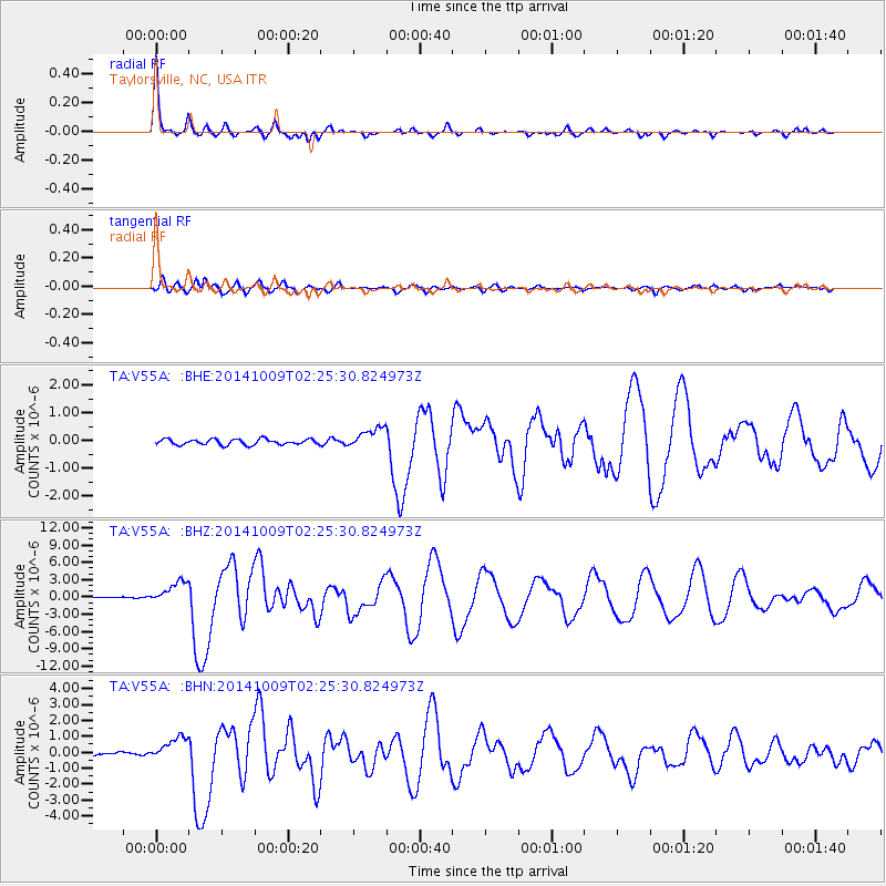
Signal To Noise
| Channel | StoN | STA | LTA |
| TA:V55A: :BHZ:20141009T02:25:30.824973Z | 15.863282 | 1.954187E-6 | 1.2318931E-7 |
| TA:V55A: :BHN:20141009T02:25:30.824973Z | 8.65746 | 7.4315034E-7 | 8.5839304E-8 |
| TA:V55A: :BHE:20141009T02:25:30.824973Z | 3.7185674 | 3.709377E-7 | 9.975286E-8 |
| Arrivals |
| Ps | 5.0 SECOND |
| PpPs | 18 SECOND |
| PsPs/PpSs | 23 SECOND |


