You are here: Home > Network List > TA - USArray Transportable Network (new EarthScope stations) Stations List
> Station V58A Windy Hill, Pittsboro, NC, USA > Earthquake Result Viewer
V58A Windy Hill, Pittsboro, NC, USA - Earthquake Result Viewer
| Earthquake location: |
Southern East Pacific Rise |
| Earthquake latitude/longitude: |
-32.1/-110.8 |
| Earthquake time(UTC): |
2014/10/09 (282) 02:14:32 GMT |
| Earthquake Depth: |
16 km |
| Earthquake Magnitude: |
7.1 MWW, 6.8 MI |
| Earthquake Catalog/Contributor: |
NEIC PDE/NEIC COMCAT |
|
| Network: |
TA USArray Transportable Network (new EarthScope stations) |
| Station: |
V58A Windy Hill, Pittsboro, NC, USA |
| Lat/Lon: |
35.79 N/79.11 W |
| Elevation: |
127 m |
|
| Distance: |
73.8 deg |
| Az: |
26.387 deg |
| Baz: |
207.638 deg |
| Ray Param: |
0.05275717 |
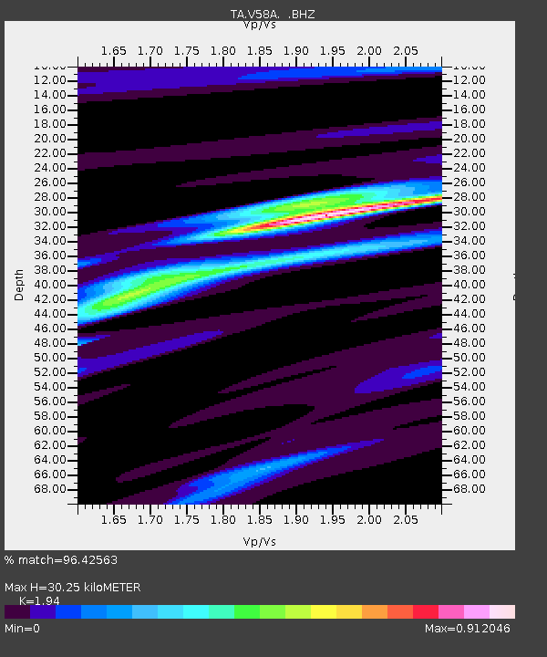
| Estimated Moho Depth: |
30.25 km |
| Estimated Crust Vp/Vs: |
1.94 |
| Assumed Crust Vp: |
6.565 km/s |
| Estimated Crust Vs: |
3.384 km/s |
| Estimated Crust Poisson's Ratio: |
0.32 |
|
| Radial Match: |
96.42563 % |
| Radial Bump: |
277 |
| Transverse Match: |
90.366684 % |
| Transverse Bump: |
400 |
| SOD ConfigId: |
803114 |
| Insert Time: |
2014-10-23 02:55:01.842 +0000 |
| GWidth: |
2.5 |
| Max Bumps: |
400 |
| Tol: |
0.001 |
|
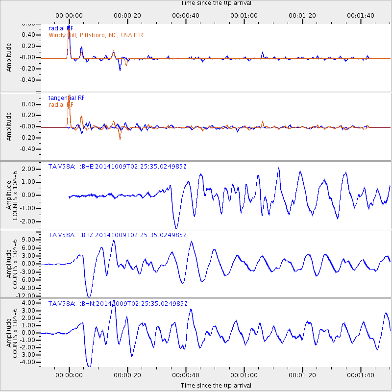
Signal To Noise
| Channel | StoN | STA | LTA |
| TA:V58A: :BHZ:20141009T02:25:35.024985Z | 21.512089 | 2.2053302E-6 | 1.0251586E-7 |
| TA:V58A: :BHN:20141009T02:25:35.024985Z | 13.687523 | 8.719956E-7 | 6.370733E-8 |
| TA:V58A: :BHE:20141009T02:25:35.024985Z | 6.1856027 | 3.9991139E-7 | 6.4651964E-8 |
| Arrivals |
| Ps | 4.5 SECOND |
| PpPs | 13 SECOND |
| PsPs/PpSs | 18 SECOND |


