You are here: Home > Network List > TA - USArray Transportable Network (new EarthScope stations) Stations List
> Station V62A Hyde County Airport, Englehard, NC, USA > Earthquake Result Viewer
V62A Hyde County Airport, Englehard, NC, USA - Earthquake Result Viewer
| Earthquake location: |
Southern East Pacific Rise |
| Earthquake latitude/longitude: |
-32.1/-110.8 |
| Earthquake time(UTC): |
2014/10/09 (282) 02:14:32 GMT |
| Earthquake Depth: |
16 km |
| Earthquake Magnitude: |
7.1 MWW, 6.8 MI |
| Earthquake Catalog/Contributor: |
NEIC PDE/NEIC COMCAT |
|
| Network: |
TA USArray Transportable Network (new EarthScope stations) |
| Station: |
V62A Hyde County Airport, Englehard, NC, USA |
| Lat/Lon: |
35.56 N/75.96 W |
| Elevation: |
-3.0 m |
|
| Distance: |
74.8 deg |
| Az: |
28.841 deg |
| Baz: |
210.136 deg |
| Ray Param: |
0.052058887 |
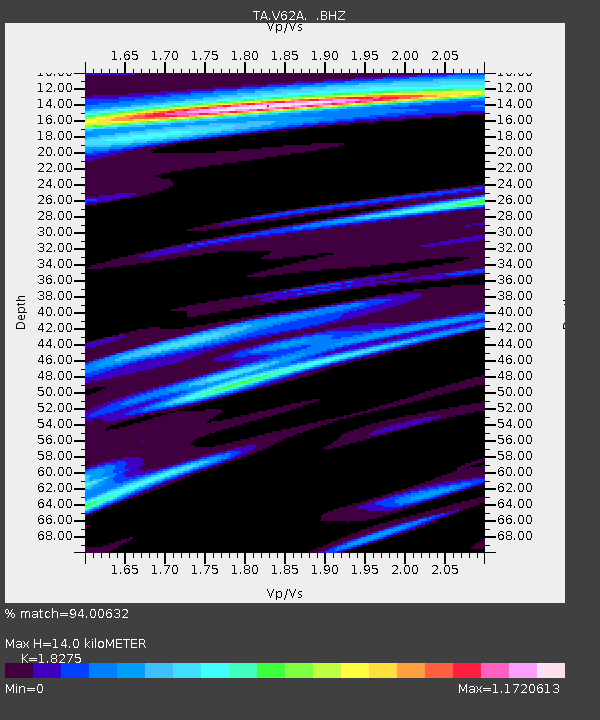
| Estimated Moho Depth: |
14.0 km |
| Estimated Crust Vp/Vs: |
1.83 |
| Assumed Crust Vp: |
5.738 km/s |
| Estimated Crust Vs: |
3.14 km/s |
| Estimated Crust Poisson's Ratio: |
0.29 |
|
| Radial Match: |
94.00632 % |
| Radial Bump: |
287 |
| Transverse Match: |
86.599724 % |
| Transverse Bump: |
380 |
| SOD ConfigId: |
803114 |
| Insert Time: |
2014-10-23 02:55:10.560 +0000 |
| GWidth: |
2.5 |
| Max Bumps: |
400 |
| Tol: |
0.001 |
|

Signal To Noise
| Channel | StoN | STA | LTA |
| TA:V62A: :BHZ:20141009T02:25:41.074973Z | 2.7950354 | 2.4301783E-6 | 8.694624E-7 |
| TA:V62A: :BHN:20141009T02:25:41.074973Z | 1.7482127 | 2.1059084E-6 | 1.2046065E-6 |
| TA:V62A: :BHE:20141009T02:25:41.074973Z | 0.8026062 | 1.1515649E-6 | 1.4347819E-6 |
| Arrivals |
| Ps | 2.1 SECOND |
| PpPs | 6.7 SECOND |
| PsPs/PpSs | 8.8 SECOND |


