You are here: Home > Network List > TA - USArray Transportable Network (new EarthScope stations) Stations List
> Station W54A Cherokee Point, Campobello, SC, USA > Earthquake Result Viewer
W54A Cherokee Point, Campobello, SC, USA - Earthquake Result Viewer
| Earthquake location: |
Southern East Pacific Rise |
| Earthquake latitude/longitude: |
-32.1/-110.8 |
| Earthquake time(UTC): |
2014/10/09 (282) 02:14:32 GMT |
| Earthquake Depth: |
16 km |
| Earthquake Magnitude: |
7.1 MWW, 6.8 MI |
| Earthquake Catalog/Contributor: |
NEIC PDE/NEIC COMCAT |
|
| Network: |
TA USArray Transportable Network (new EarthScope stations) |
| Station: |
W54A Cherokee Point, Campobello, SC, USA |
| Lat/Lon: |
35.09 N/82.19 W |
| Elevation: |
272 m |
|
| Distance: |
72.0 deg |
| Az: |
24.368 deg |
| Baz: |
205.272 deg |
| Ray Param: |
0.0539136 |
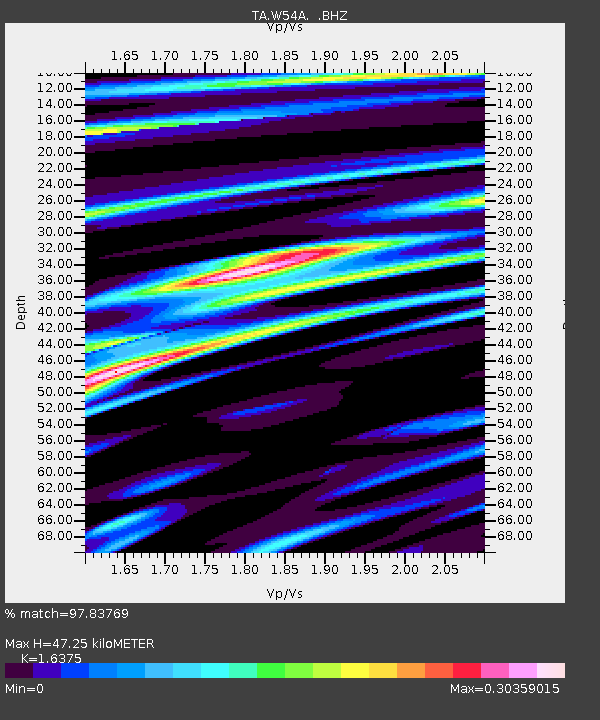
| Estimated Moho Depth: |
47.25 km |
| Estimated Crust Vp/Vs: |
1.64 |
| Assumed Crust Vp: |
6.35 km/s |
| Estimated Crust Vs: |
3.878 km/s |
| Estimated Crust Poisson's Ratio: |
0.20 |
|
| Radial Match: |
97.83769 % |
| Radial Bump: |
298 |
| Transverse Match: |
85.12227 % |
| Transverse Bump: |
400 |
| SOD ConfigId: |
803114 |
| Insert Time: |
2014-10-23 02:55:20.561 +0000 |
| GWidth: |
2.5 |
| Max Bumps: |
400 |
| Tol: |
0.001 |
|

Signal To Noise
| Channel | StoN | STA | LTA |
| TA:W54A: :BHZ:20141009T02:25:24.699973Z | 14.974458 | 1.8737611E-6 | 1.2513048E-7 |
| TA:W54A: :BHN:20141009T02:25:24.699973Z | 8.282598 | 6.870622E-7 | 8.29525E-8 |
| TA:W54A: :BHE:20141009T02:25:24.699973Z | 3.9516444 | 3.346982E-7 | 8.4698456E-8 |
| Arrivals |
| Ps | 4.9 SECOND |
| PpPs | 19 SECOND |
| PsPs/PpSs | 24 SECOND |


