You are here: Home > Network List > TA - USArray Transportable Network (new EarthScope stations) Stations List
> Station X57A Johnson Farm, Hartsville, SC, USA > Earthquake Result Viewer
X57A Johnson Farm, Hartsville, SC, USA - Earthquake Result Viewer
| Earthquake location: |
Southern East Pacific Rise |
| Earthquake latitude/longitude: |
-32.1/-110.8 |
| Earthquake time(UTC): |
2014/10/09 (282) 02:14:32 GMT |
| Earthquake Depth: |
16 km |
| Earthquake Magnitude: |
7.1 MWW, 6.8 MI |
| Earthquake Catalog/Contributor: |
NEIC PDE/NEIC COMCAT |
|
| Network: |
TA USArray Transportable Network (new EarthScope stations) |
| Station: |
X57A Johnson Farm, Hartsville, SC, USA |
| Lat/Lon: |
34.46 N/80.09 W |
| Elevation: |
133 m |
|
| Distance: |
72.2 deg |
| Az: |
26.279 deg |
| Baz: |
207.046 deg |
| Ray Param: |
0.053778052 |
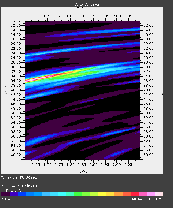
| Estimated Moho Depth: |
35.0 km |
| Estimated Crust Vp/Vs: |
1.64 |
| Assumed Crust Vp: |
6.419 km/s |
| Estimated Crust Vs: |
3.902 km/s |
| Estimated Crust Poisson's Ratio: |
0.21 |
|
| Radial Match: |
98.30291 % |
| Radial Bump: |
285 |
| Transverse Match: |
88.48555 % |
| Transverse Bump: |
400 |
| SOD ConfigId: |
803114 |
| Insert Time: |
2014-10-23 02:55:49.460 +0000 |
| GWidth: |
2.5 |
| Max Bumps: |
400 |
| Tol: |
0.001 |
|

Signal To Noise
| Channel | StoN | STA | LTA |
| TA:X57A: :BHZ:20141009T02:25:25.899985Z | 16.223745 | 1.9804133E-6 | 1.2206881E-7 |
| TA:X57A: :BHN:20141009T02:25:25.899985Z | 6.98484 | 8.5596827E-7 | 1.2254658E-7 |
| TA:X57A: :BHE:20141009T02:25:25.899985Z | 4.101131 | 5.055839E-7 | 1.2327914E-7 |
| Arrivals |
| Ps | 3.7 SECOND |
| PpPs | 14 SECOND |
| PsPs/PpSs | 18 SECOND |


