You are here: Home > Network List > TA - USArray Transportable Network (new EarthScope stations) Stations List
> Station X60A Albert Glenn Thornton, NC, USA > Earthquake Result Viewer
X60A Albert Glenn Thornton, NC, USA - Earthquake Result Viewer
| Earthquake location: |
Southern East Pacific Rise |
| Earthquake latitude/longitude: |
-32.1/-110.8 |
| Earthquake time(UTC): |
2014/10/09 (282) 02:14:32 GMT |
| Earthquake Depth: |
16 km |
| Earthquake Magnitude: |
7.1 MWW, 6.8 MI |
| Earthquake Catalog/Contributor: |
NEIC PDE/NEIC COMCAT |
|
| Network: |
TA USArray Transportable Network (new EarthScope stations) |
| Station: |
X60A Albert Glenn Thornton, NC, USA |
| Lat/Lon: |
34.58 N/77.98 W |
| Elevation: |
12 m |
|
| Distance: |
73.2 deg |
| Az: |
27.842 deg |
| Baz: |
208.705 deg |
| Ray Param: |
0.053175066 |
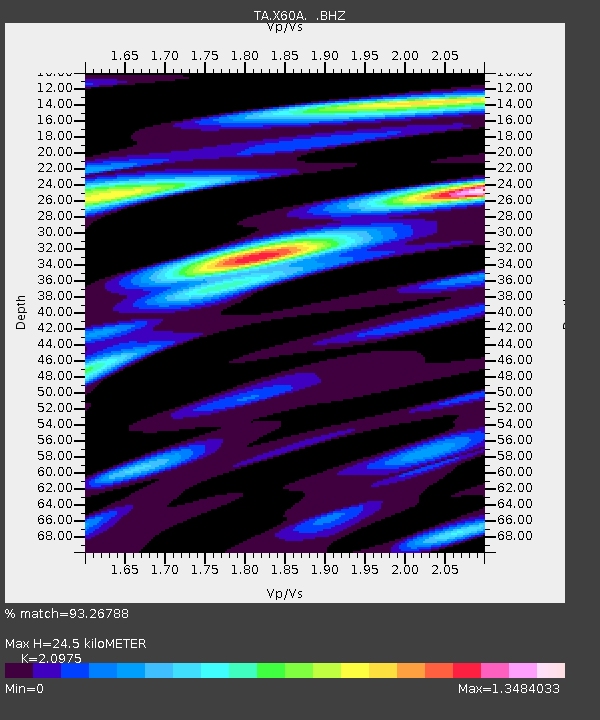
| Estimated Moho Depth: |
24.5 km |
| Estimated Crust Vp/Vs: |
2.10 |
| Assumed Crust Vp: |
6.565 km/s |
| Estimated Crust Vs: |
3.13 km/s |
| Estimated Crust Poisson's Ratio: |
0.35 |
|
| Radial Match: |
93.26788 % |
| Radial Bump: |
400 |
| Transverse Match: |
86.72389 % |
| Transverse Bump: |
400 |
| SOD ConfigId: |
803114 |
| Insert Time: |
2014-10-23 02:55:54.407 +0000 |
| GWidth: |
2.5 |
| Max Bumps: |
400 |
| Tol: |
0.001 |
|
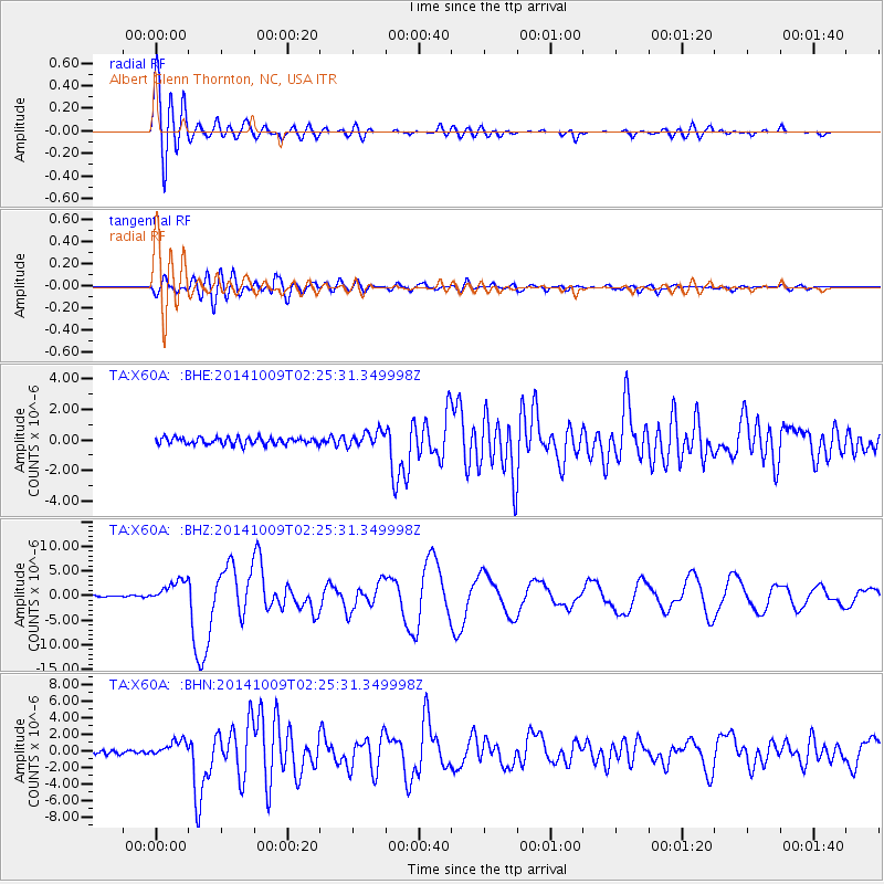
Signal To Noise
| Channel | StoN | STA | LTA |
| TA:X60A: :BHZ:20141009T02:25:31.349998Z | 15.946554 | 2.3114521E-6 | 1.4494995E-7 |
| TA:X60A: :BHN:20141009T02:25:31.349998Z | 3.655628 | 9.812827E-7 | 2.6843068E-7 |
| TA:X60A: :BHE:20141009T02:25:31.349998Z | 2.2514102 | 5.0204875E-7 | 2.22993E-7 |
| Arrivals |
| Ps | 4.2 SECOND |
| PpPs | 11 SECOND |
| PsPs/PpSs | 15 SECOND |


