You are here: Home > Network List > TA - USArray Transportable Network (new EarthScope stations) Stations List
> Station Y56A Pelion, SC, USA > Earthquake Result Viewer
Y56A Pelion, SC, USA - Earthquake Result Viewer

| Earthquake location: |
Southern East Pacific Rise |
| Earthquake latitude/longitude: |
-32.1/-110.8 |
| Earthquake time(UTC): |
2014/10/09 (282) 02:14:32 GMT |
| Earthquake Depth: |
16 km |
| Earthquake Magnitude: |
7.1 MWW, 6.8 MI |
| Earthquake Catalog/Contributor: |
NEIC PDE/NEIC COMCAT |
|
| Network: |
TA USArray Transportable Network (new EarthScope stations) |
| Station: |
Y56A Pelion, SC, USA |
| Lat/Lon: |
33.79 N/81.30 W |
| Elevation: |
154 m |
|
| Distance: |
71.2 deg |
| Az: |
25.649 deg |
| Baz: |
206.172 deg |
| Ray Param: |
0.054474223 |
| Estimated Moho Depth: |
34.5 km |
| Estimated Crust Vp/Vs: |
1.68 |
| Assumed Crust Vp: |
6.565 km/s |
| Estimated Crust Vs: |
3.919 km/s |
| Estimated Crust Poisson's Ratio: |
0.22 |
|
| Radial Match: |
98.27086 % |
| Radial Bump: |
292 |
| Transverse Match: |
80.08644 % |
| Transverse Bump: |
400 |
| SOD ConfigId: |
803114 |
| Insert Time: |
2014-10-23 02:55:59.644 +0000 |
| GWidth: |
2.5 |
| Max Bumps: |
400 |
| Tol: |
0.001 |
|
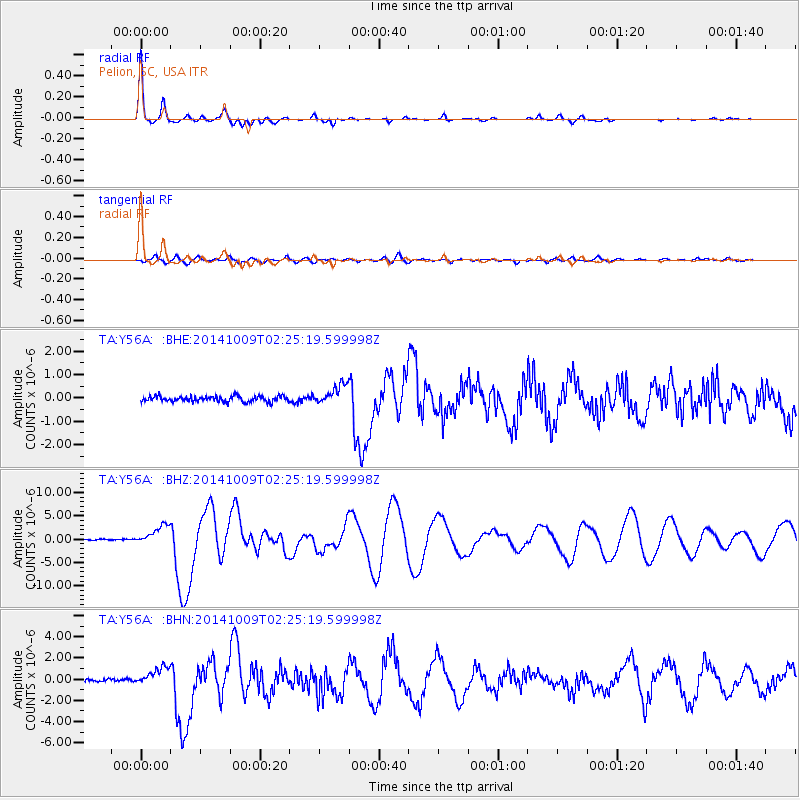
Signal To Noise
| Channel | StoN | STA | LTA |
| TA:Y56A: :BHZ:20141009T02:25:19.599998Z | 20.959099 | 2.102465E-6 | 1.00312754E-7 |
| TA:Y56A: :BHN:20141009T02:25:19.599998Z | 6.787896 | 9.127549E-7 | 1.3446801E-7 |
| TA:Y56A: :BHE:20141009T02:25:19.599998Z | 3.4703598 | 4.2369527E-7 | 1.2208973E-7 |
| Arrivals |
| Ps | 3.7 SECOND |
| PpPs | 14 SECOND |
| PsPs/PpSs | 17 SECOND |


