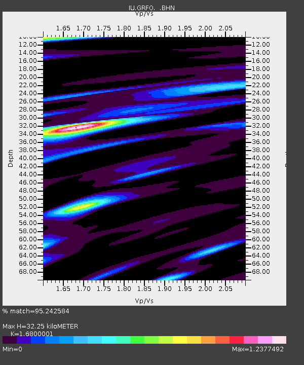
GRFO Grafenberg, Germany - Earthquake Result Viewer

Earthquake location: Andaman Islands, India Region
Earthquake latitude/longitude: 11.0/91.8
Earthquake time(UTC): 2008/06/27 (179) 11:40:13 GMT
Earthquake Depth: 17 km
Earthquake Magnitude: 6.4 MB, 6.7 MS, 6.6 MW, 6.6 MW
Earthquake Catalog/Contributor: WHDF/NEIC
Network: IU Global Seismograph Network (GSN - IRIS/USGS)
Station: GRFO Grafenberg, Germany
Lat/Lon: 49.69 N/11.22 E
Elevation: 384 m
Distance: 75.6 deg
Az: 318.59 deg
Baz: 89.924 deg
Ray Param: 0.05153175
Estimated Moho Depth: 32.25 km
Estimated Crust Vp/Vs: 1.68
Assumed Crust Vp: 6.182 km/s
Estimated Crust Vs: 3.68 km/s
Estimated Crust Poisson's Ratio: 0.23
Radial Match: 95.242584 %
Radial Bump: 400
Transverse Match: 82.458916 %
Transverse Bump: 400
SOD ConfigId: 2504
Insert Time: 2010-03-02 02:11:18.990 +0000
GWidth: 2.5
Max Bumps: 400
Tol: 0.001

Signal To Noise

ChannelStoNSTALTA
IU:GRFO: :BHN:20080627T11:51:26.620005Z21.256432.194608E-61.0324443E-7
IU:GRFO: :BHE:20080627T11:51:26.620005Z1.47399011.4477378E-79.821896E-8
IU:GRFO: :BHZ:20080627T11:51:26.620005Z6.39684721.0930091E-61.7086684E-7
Arrivals
Ps3.7 SECOND
PpPs14 SECOND
PsPs/PpSs17 SECOND