You are here: Home > Network List > UU - University of Utah Regional Network Stations List
> Station ASI2 Darling Creek, Challis, ID, USA > Earthquake Result Viewer
ASI2 Darling Creek, Challis, ID, USA - Earthquake Result Viewer
| Earthquake location: |
Southern East Pacific Rise |
| Earthquake latitude/longitude: |
-32.1/-110.8 |
| Earthquake time(UTC): |
2014/10/09 (282) 02:14:32 GMT |
| Earthquake Depth: |
16 km |
| Earthquake Magnitude: |
7.1 MWW, 6.8 MI |
| Earthquake Catalog/Contributor: |
NEIC PDE/NEIC COMCAT |
|
| Network: |
UU University of Utah Regional Network |
| Station: |
ASI2 Darling Creek, Challis, ID, USA |
| Lat/Lon: |
44.57 N/114.26 W |
| Elevation: |
1600 m |
|
| Distance: |
76.4 deg |
| Az: |
357.443 deg |
| Baz: |
176.963 deg |
| Ray Param: |
0.051016387 |
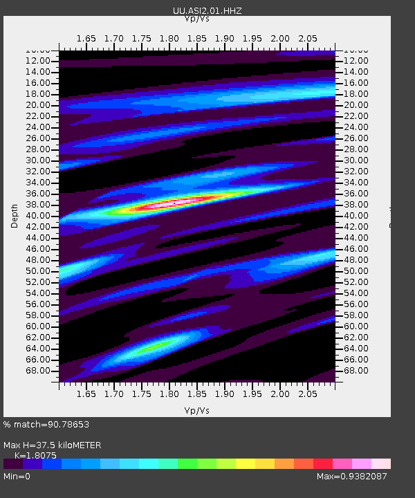
| Estimated Moho Depth: |
37.5 km |
| Estimated Crust Vp/Vs: |
1.81 |
| Assumed Crust Vp: |
6.577 km/s |
| Estimated Crust Vs: |
3.639 km/s |
| Estimated Crust Poisson's Ratio: |
0.28 |
|
| Radial Match: |
90.78653 % |
| Radial Bump: |
400 |
| Transverse Match: |
73.15546 % |
| Transverse Bump: |
400 |
| SOD ConfigId: |
803114 |
| Insert Time: |
2014-10-23 03:00:00.788 +0000 |
| GWidth: |
2.5 |
| Max Bumps: |
400 |
| Tol: |
0.001 |
|

Signal To Noise
| Channel | StoN | STA | LTA |
| UU:ASI2:01:HHZ:20141009T02:25:49.974021Z | 3.7276342 | 2.6389642E-8 | 7.0794615E-9 |
| UU:ASI2:01:HHN:20141009T02:25:49.974021Z | 0.4941557 | 5.951525E-9 | 1.20438255E-8 |
| UU:ASI2:01:HHE:20141009T02:25:49.974021Z | 0.9919553 | 1.8205332E-8 | 1.8352978E-8 |
| Arrivals |
| Ps | 4.8 SECOND |
| PpPs | 15 SECOND |
| PsPs/PpSs | 20 SECOND |


