You are here: Home > Network List > US - United States National Seismic Network Stations List
> Station HAWA Hanford, Washington, USA > Earthquake Result Viewer
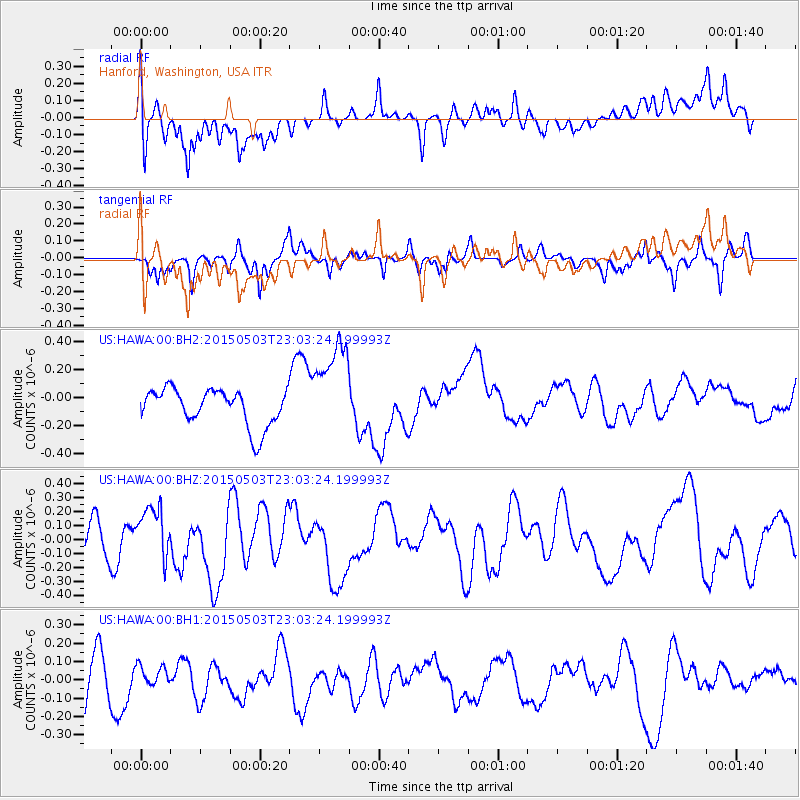
HAWA Hanford, Washington, USA - Earthquake Result Viewer
*The percent match for this event was below the threshold and hence no stack was calculated.
| Earthquake location: |
New Britain Region, P.N.G. |
| Earthquake latitude/longitude: |
-5.5/151.9 |
| Earthquake time(UTC): |
2015/05/03 (123) 22:50:47 GMT |
| Earthquake Depth: |
45 km |
| Earthquake Magnitude: |
5.4 MW |
| Earthquake Catalog/Contributor: |
ISC/ISC |
|
| Network: |
US United States National Seismic Network |
| Station: |
HAWA Hanford, Washington, USA |
| Lat/Lon: |
46.39 N/119.53 W |
| Elevation: |
364 m |
|
| Distance: |
93.0 deg |
| Az: |
43.858 deg |
| Baz: |
265.228 deg |
| Ray Param: |
$rayparam |
*The percent match for this event was below the threshold and hence was not used in the summary stack. |
|
| Radial Match: |
39.309883 % |
| Radial Bump: |
400 |
| Transverse Match: |
62.0408 % |
| Transverse Bump: |
341 |
| SOD ConfigId: |
7422571 |
| Insert Time: |
2019-04-18 15:42:42.308 +0000 |
| GWidth: |
2.5 |
| Max Bumps: |
400 |
| Tol: |
0.001 |
|
Signal To Noise
| Channel | StoN | STA | LTA |
| US:HAWA:00:BHZ:20150503T23:03:24.199993Z | 1.318713 | 1.8703702E-7 | 1.41833E-7 |
| US:HAWA:00:BH1:20150503T23:03:24.199993Z | 0.3825404 | 5.292943E-8 | 1.3836299E-7 |
| US:HAWA:00:BH2:20150503T23:03:24.199993Z | 2.6146123 | 3.434334E-7 | 1.3135157E-7 |
| Arrivals |
| Ps | |
| PpPs | |
| PsPs/PpSs | |


