You are here: Home > Network List > UW - Pacific Northwest Regional Seismic Network Stations List
> Station GNW Green Mountain (BB) > Earthquake Result Viewer
GNW Green Mountain (BB) - Earthquake Result Viewer

| Earthquake location: |
Southern East Pacific Rise |
| Earthquake latitude/longitude: |
-32.1/-110.8 |
| Earthquake time(UTC): |
2014/10/09 (282) 02:14:32 GMT |
| Earthquake Depth: |
16 km |
| Earthquake Magnitude: |
7.1 MWW, 6.8 MI |
| Earthquake Catalog/Contributor: |
NEIC PDE/NEIC COMCAT |
|
| Network: |
UW Pacific Northwest Regional Seismic Network |
| Station: |
GNW Green Mountain (BB) |
| Lat/Lon: |
47.56 N/122.83 W |
| Elevation: |
160 m |
|
| Distance: |
80.1 deg |
| Az: |
351.75 deg |
| Baz: |
169.642 deg |
| Ray Param: |
0.04853076 |
| Estimated Moho Depth: |
16.5 km |
| Estimated Crust Vp/Vs: |
2.09 |
| Assumed Crust Vp: |
6.566 km/s |
| Estimated Crust Vs: |
3.138 km/s |
| Estimated Crust Poisson's Ratio: |
0.35 |
|
| Radial Match: |
97.36877 % |
| Radial Bump: |
226 |
| Transverse Match: |
89.5343 % |
| Transverse Bump: |
341 |
| SOD ConfigId: |
803114 |
| Insert Time: |
2014-10-23 03:00:21.240 +0000 |
| GWidth: |
2.5 |
| Max Bumps: |
400 |
| Tol: |
0.001 |
|
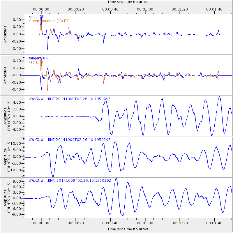
Signal To Noise
| Channel | StoN | STA | LTA |
| UW:GNW: :BHZ:20141009T02:26:10.195029Z | 19.224682 | 2.321807E-6 | 1.2077219E-7 |
| UW:GNW: :BHN:20141009T02:26:10.195029Z | 9.451473 | 7.913415E-7 | 8.372679E-8 |
| UW:GNW: :BHE:20141009T02:26:10.195029Z | 8.186964 | 7.5375397E-7 | 9.206758E-8 |
| Arrivals |
| Ps | 2.8 SECOND |
| PpPs | 7.6 SECOND |
| PsPs/PpSs | 10 SECOND |


