You are here: Home > Network List > IU - Global Seismograph Network (GSN - IRIS/USGS) Stations List
> Station GRFO Grafenberg, Germany > Earthquake Result Viewer
GRFO Grafenberg, Germany - Earthquake Result Viewer
| Earthquake location: |
Primor'ye, Russia |
| Earthquake latitude/longitude: |
42.3/132.9 |
| Earthquake time(UTC): |
1994/07/21 (202) 18:36:31 GMT |
| Earthquake Depth: |
473 km |
| Earthquake Magnitude: |
6.4 MB, 7.2 UNKNOWN |
| Earthquake Catalog/Contributor: |
WHDF/NEIC |
|
| Network: |
IU Global Seismograph Network (GSN - IRIS/USGS) |
| Station: |
GRFO Grafenberg, Germany |
| Lat/Lon: |
49.69 N/11.22 E |
| Elevation: |
425 m |
|
| Distance: |
75.1 deg |
| Az: |
325.116 deg |
| Baz: |
40.793 deg |
| Ray Param: |
0.05043932 |
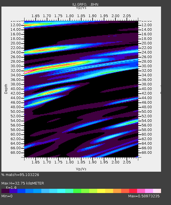
| Estimated Moho Depth: |
32.75 km |
| Estimated Crust Vp/Vs: |
1.60 |
| Assumed Crust Vp: |
6.182 km/s |
| Estimated Crust Vs: |
3.864 km/s |
| Estimated Crust Poisson's Ratio: |
0.18 |
|
| Radial Match: |
95.103226 % |
| Radial Bump: |
274 |
| Transverse Match: |
86.26962 % |
| Transverse Bump: |
400 |
| SOD ConfigId: |
16938 |
| Insert Time: |
2010-03-02 02:12:23.213 +0000 |
| GWidth: |
2.5 |
| Max Bumps: |
400 |
| Tol: |
0.001 |
|

Signal To Noise
| Channel | StoN | STA | LTA |
| IU:GRFO: :BHN:19940721T18:46:53.369006Z | 50.275085 | 3.5093638E-6 | 6.980324E-8 |
| IU:GRFO: :BHE:19940721T18:46:53.369006Z | 45.6037 | 2.7460799E-6 | 6.0216166E-8 |
| IU:GRFO: :BHZ:19940721T18:46:53.369006Z | 149.87709 | 1.1472798E-5 | 7.654804E-8 |
| Arrivals |
| Ps | 3.3 SECOND |
| PpPs | 13 SECOND |
| PsPs/PpSs | 17 SECOND |


