You are here: Home > Network List > WY - Yellowstone Wyoming Seismic Network Stations List
> Station YNE Northeast Entrance, YNP, WY, USA > Earthquake Result Viewer
YNE Northeast Entrance, YNP, WY, USA - Earthquake Result Viewer
| Earthquake location: |
Southern East Pacific Rise |
| Earthquake latitude/longitude: |
-32.1/-110.8 |
| Earthquake time(UTC): |
2014/10/09 (282) 02:14:32 GMT |
| Earthquake Depth: |
16 km |
| Earthquake Magnitude: |
7.1 MWW, 6.8 MI |
| Earthquake Catalog/Contributor: |
NEIC PDE/NEIC COMCAT |
|
| Network: |
WY Yellowstone Wyoming Seismic Network |
| Station: |
YNE Northeast Entrance, YNP, WY, USA |
| Lat/Lon: |
45.01 N/110.01 W |
| Elevation: |
2343 m |
|
| Distance: |
76.8 deg |
| Az: |
0.562 deg |
| Baz: |
180.672 deg |
| Ray Param: |
0.050767567 |
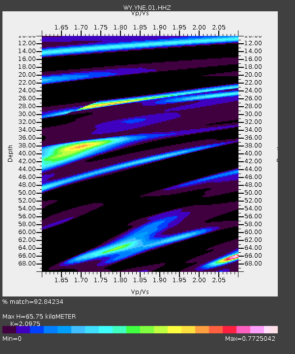
| Estimated Moho Depth: |
65.75 km |
| Estimated Crust Vp/Vs: |
2.10 |
| Assumed Crust Vp: |
6.35 km/s |
| Estimated Crust Vs: |
3.027 km/s |
| Estimated Crust Poisson's Ratio: |
0.35 |
|
| Radial Match: |
92.84234 % |
| Radial Bump: |
344 |
| Transverse Match: |
81.22846 % |
| Transverse Bump: |
400 |
| SOD ConfigId: |
803114 |
| Insert Time: |
2014-10-23 03:03:29.079 +0000 |
| GWidth: |
2.5 |
| Max Bumps: |
400 |
| Tol: |
0.001 |
|

Signal To Noise
| Channel | StoN | STA | LTA |
| WY:YNE:01:HHZ:20141009T02:25:52.065024Z | 26.033714 | 9.4541214E-8 | 3.6314913E-9 |
| WY:YNE:01:HHN:20141009T02:25:52.065024Z | 3.7434545 | 3.440729E-8 | 9.191321E-9 |
| WY:YNE:01:HHE:20141009T02:25:52.065024Z | 0.54335797 | 4.850265E-9 | 8.926463E-9 |
| Arrivals |
| Ps | 12 SECOND |
| PpPs | 31 SECOND |
| PsPs/PpSs | 43 SECOND |


