You are here: Home > Network List > C1 - Red Sismologica Nacional Stations List
> Station TA01 Daracena > Earthquake Result Viewer
TA01 Daracena - Earthquake Result Viewer
| Earthquake location: |
Southern East Pacific Rise |
| Earthquake latitude/longitude: |
-32.1/-110.8 |
| Earthquake time(UTC): |
2014/10/09 (282) 02:14:32 GMT |
| Earthquake Depth: |
16 km |
| Earthquake Magnitude: |
7.1 MWW, 6.8 MI |
| Earthquake Catalog/Contributor: |
NEIC PDE/NEIC COMCAT |
|
| Network: |
C1 Red Sismologica Nacional |
| Station: |
TA01 Daracena |
| Lat/Lon: |
20.57 S/70.18 W |
| Elevation: |
616 m |
|
| Distance: |
38.0 deg |
| Az: |
82.519 deg |
| Baz: |
243.882 deg |
| Ray Param: |
0.07582818 |
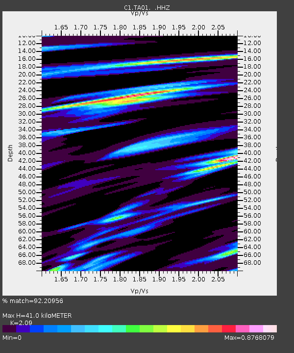
| Estimated Moho Depth: |
41.0 km |
| Estimated Crust Vp/Vs: |
2.09 |
| Assumed Crust Vp: |
4.24 km/s |
| Estimated Crust Vs: |
2.029 km/s |
| Estimated Crust Poisson's Ratio: |
0.35 |
|
| Radial Match: |
92.20956 % |
| Radial Bump: |
239 |
| Transverse Match: |
76.326935 % |
| Transverse Bump: |
400 |
| SOD ConfigId: |
803114 |
| Insert Time: |
2014-10-23 03:05:53.360 +0000 |
| GWidth: |
2.5 |
| Max Bumps: |
400 |
| Tol: |
0.001 |
|

Signal To Noise
| Channel | StoN | STA | LTA |
| C1:TA01: :HHZ:20141009T02:21:18.790Z | 5.7547274 | 1.5766852E-6 | 2.7398087E-7 |
| C1:TA01: :HHN:20141009T02:21:18.790Z | 1.780173 | 5.7313446E-7 | 3.219544E-7 |
| C1:TA01: :HHE:20141009T02:21:18.790Z | 5.158974 | 1.1734388E-6 | 2.2745586E-7 |
| Arrivals |
| Ps | 11 SECOND |
| PpPs | 29 SECOND |
| PsPs/PpSs | 40 SECOND |


