You are here: Home > Network List > AV - Alaska Volcano Observatory Stations List
> Station SPCR Ckakachatna River, Mount Spurr, Alaska > Earthquake Result Viewer
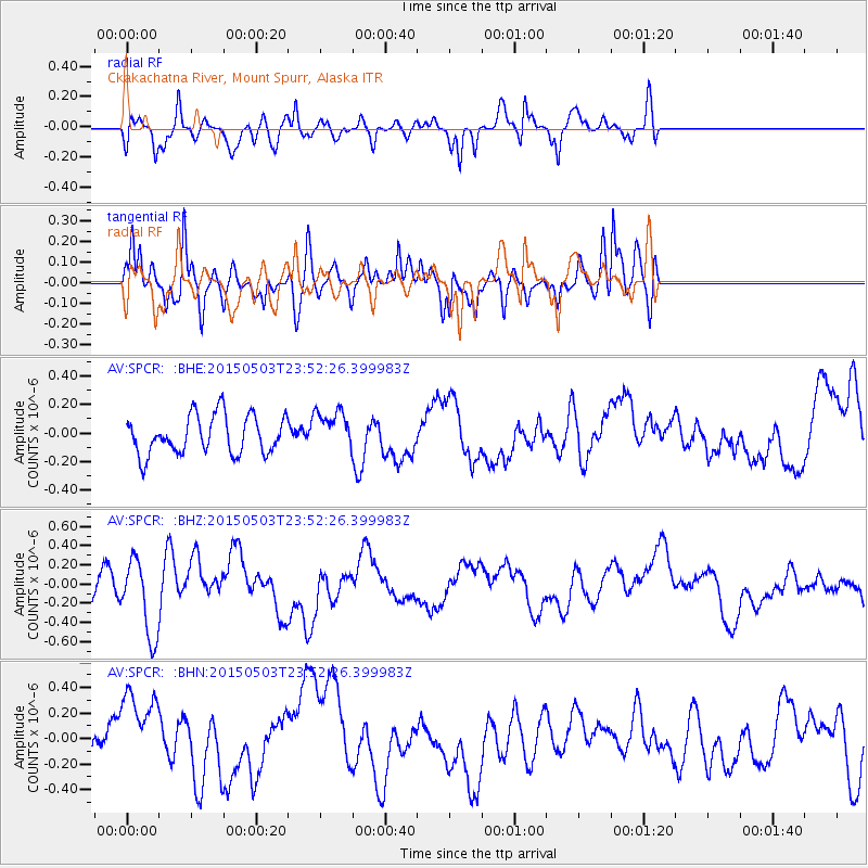
SPCR Ckakachatna River, Mount Spurr, Alaska - Earthquake Result Viewer
*The percent match for this event was below the threshold and hence no stack was calculated.
| Earthquake location: |
New Britain Region, P.N.G. |
| Earthquake latitude/longitude: |
-5.5/151.9 |
| Earthquake time(UTC): |
2015/05/03 (123) 23:40:55 GMT |
| Earthquake Depth: |
35 km |
| Earthquake Magnitude: |
5.9 MWW, 5.7 MWB, 5.8 MWC |
| Earthquake Catalog/Contributor: |
NEIC PDE/NEIC COMCAT |
|
| Network: |
AV Alaska Volcano Observatory |
| Station: |
SPCR Ckakachatna River, Mount Spurr, Alaska |
| Lat/Lon: |
61.20 N/152.21 W |
| Elevation: |
984 m |
|
| Distance: |
79.3 deg |
| Az: |
24.081 deg |
| Baz: |
237.006 deg |
| Ray Param: |
$rayparam |
*The percent match for this event was below the threshold and hence was not used in the summary stack. |
|
| Radial Match: |
54.450394 % |
| Radial Bump: |
380 |
| Transverse Match: |
61.262108 % |
| Transverse Bump: |
371 |
| SOD ConfigId: |
7422571 |
| Insert Time: |
2019-04-18 15:44:53.131 +0000 |
| GWidth: |
2.5 |
| Max Bumps: |
400 |
| Tol: |
0.001 |
|
Signal To Noise
| Channel | StoN | STA | LTA |
| AV:SPCR: :BHZ:20150503T23:52:26.399983Z | 2.9378905 | 3.983152E-7 | 1.3557863E-7 |
| AV:SPCR: :BHN:20150503T23:52:26.399983Z | 1.4360148 | 3.2162052E-7 | 2.2396743E-7 |
| AV:SPCR: :BHE:20150503T23:52:26.399983Z | 1.0586431 | 1.4254479E-7 | 1.3464857E-7 |
| Arrivals |
| Ps | |
| PpPs | |
| PsPs/PpSs | |


