You are here: Home > Network List > IU - Global Seismograph Network (GSN - IRIS/USGS) Stations List
> Station GRFO Grafenberg, Germany > Earthquake Result Viewer
GRFO Grafenberg, Germany - Earthquake Result Viewer
| Earthquake location: |
Kuril Islands |
| Earthquake latitude/longitude: |
43.7/147.3 |
| Earthquake time(UTC): |
1994/10/04 (277) 13:22:58 GMT |
| Earthquake Depth: |
33 km |
| Earthquake Magnitude: |
7.4 MB, 8.1 MS, 8.3 UNKNOWN, 8.2 MW |
| Earthquake Catalog/Contributor: |
WHDF/NEIC |
|
| Network: |
IU Global Seismograph Network (GSN - IRIS/USGS) |
| Station: |
GRFO Grafenberg, Germany |
| Lat/Lon: |
49.69 N/11.22 E |
| Elevation: |
425 m |
|
| Distance: |
79.4 deg |
| Az: |
332.736 deg |
| Baz: |
30.767 deg |
| Ray Param: |
0.04895075 |
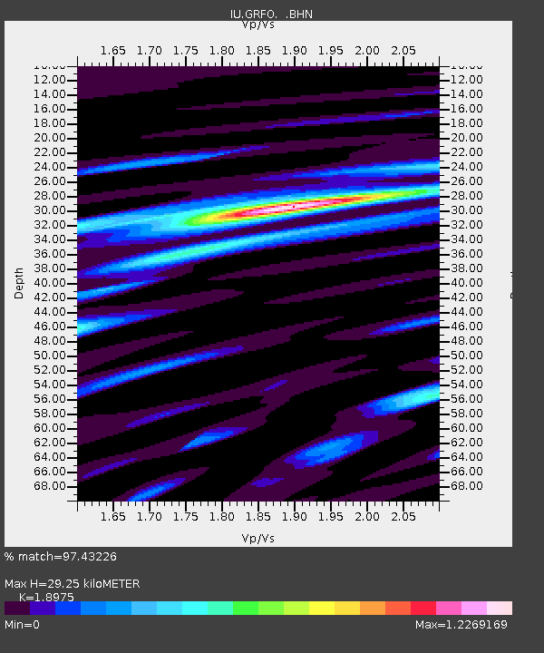
| Estimated Moho Depth: |
29.25 km |
| Estimated Crust Vp/Vs: |
1.90 |
| Assumed Crust Vp: |
6.182 km/s |
| Estimated Crust Vs: |
3.258 km/s |
| Estimated Crust Poisson's Ratio: |
0.31 |
|
| Radial Match: |
97.43226 % |
| Radial Bump: |
398 |
| Transverse Match: |
91.96641 % |
| Transverse Bump: |
400 |
| SOD ConfigId: |
17000 |
| Insert Time: |
2010-03-02 02:13:17.687 +0000 |
| GWidth: |
2.5 |
| Max Bumps: |
400 |
| Tol: |
0.001 |
|

Signal To Noise
| Channel | StoN | STA | LTA |
| IU:GRFO: :BHN:19941004T13:34:29.927014Z | 3.7082458 | 4.5829893E-6 | 1.2358914E-6 |
| IU:GRFO: :BHE:19941004T13:34:29.927014Z | 3.4993708 | 2.2138665E-6 | 6.32647E-7 |
| IU:GRFO: :BHZ:19941004T13:34:29.927014Z | 3.9162629 | 1.0260473E-5 | 2.6199652E-6 |
| Arrivals |
| Ps | 4.4 SECOND |
| PpPs | 13 SECOND |
| PsPs/PpSs | 18 SECOND |


