You are here: Home > Network List > IU - Global Seismograph Network (GSN - IRIS/USGS) Stations List
> Station GRFO Grafenberg, Germany > Earthquake Result Viewer
GRFO Grafenberg, Germany - Earthquake Result Viewer
| Earthquake location: |
Chiapas, Mexico |
| Earthquake latitude/longitude: |
16.9/-93.5 |
| Earthquake time(UTC): |
1995/10/21 (294) 02:38:57 GMT |
| Earthquake Depth: |
161 km |
| Earthquake Magnitude: |
6.2 MB, 7.3 UNKNOWN, 7.3 MW |
| Earthquake Catalog/Contributor: |
WHDF/NEIC |
|
| Network: |
IU Global Seismograph Network (GSN - IRIS/USGS) |
| Station: |
GRFO Grafenberg, Germany |
| Lat/Lon: |
49.69 N/11.22 E |
| Elevation: |
425 m |
|
| Distance: |
86.4 deg |
| Az: |
39.01 deg |
| Baz: |
291.879 deg |
| Ray Param: |
0.04368126 |
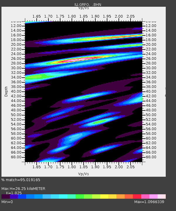
| Estimated Moho Depth: |
26.25 km |
| Estimated Crust Vp/Vs: |
1.83 |
| Assumed Crust Vp: |
6.182 km/s |
| Estimated Crust Vs: |
3.388 km/s |
| Estimated Crust Poisson's Ratio: |
0.29 |
|
| Radial Match: |
95.019165 % |
| Radial Bump: |
400 |
| Transverse Match: |
83.07196 % |
| Transverse Bump: |
400 |
| SOD ConfigId: |
6273 |
| Insert Time: |
2010-03-02 02:13:35.393 +0000 |
| GWidth: |
2.5 |
| Max Bumps: |
400 |
| Tol: |
0.001 |
|

Signal To Noise
| Channel | StoN | STA | LTA |
| IU:GRFO: :BHN:19951021T02:50:50.669006Z | 1.1542408 | 2.9213888E-7 | 2.5310044E-7 |
| IU:GRFO: :BHE:19951021T02:50:50.669006Z | 3.456237 | 8.539758E-7 | 2.470825E-7 |
| IU:GRFO: :BHZ:19951021T02:50:50.669006Z | 13.20672 | 2.1790918E-6 | 1.6499871E-7 |
| Arrivals |
| Ps | 3.6 SECOND |
| PpPs | 12 SECOND |
| PsPs/PpSs | 15 SECOND |


