You are here: Home > Network List > CU - Caribbean Network (USGS) Stations List
> Station BBGH Gun Hill, Barbados > Earthquake Result Viewer
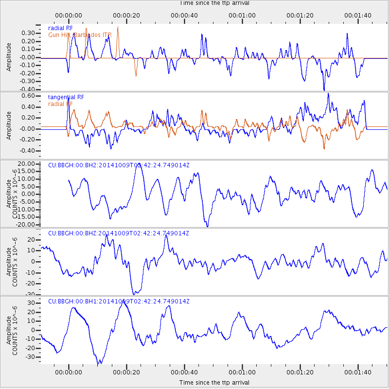
BBGH Gun Hill, Barbados - Earthquake Result Viewer
*The percent match for this event was below the threshold and hence no stack was calculated.
| Earthquake location: |
Southern East Pacific Rise |
| Earthquake latitude/longitude: |
-32.1/-110.9 |
| Earthquake time(UTC): |
2014/10/09 (282) 02:32:05 GMT |
| Earthquake Depth: |
10 km |
| Earthquake Magnitude: |
6.6 MWW, 6.6 MWC |
| Earthquake Catalog/Contributor: |
NEIC PDE/NEIC COMCAT |
|
| Network: |
CU Caribbean Network (USGS) |
| Station: |
BBGH Gun Hill, Barbados |
| Lat/Lon: |
13.14 N/59.56 W |
| Elevation: |
180 m |
|
| Distance: |
66.6 deg |
| Az: |
55.964 deg |
| Baz: |
226.214 deg |
| Ray Param: |
$rayparam |
*The percent match for this event was below the threshold and hence was not used in the summary stack. |
|
| Radial Match: |
65.67609 % |
| Radial Bump: |
400 |
| Transverse Match: |
43.233463 % |
| Transverse Bump: |
400 |
| SOD ConfigId: |
803114 |
| Insert Time: |
2014-10-23 03:15:40.319 +0000 |
| GWidth: |
2.5 |
| Max Bumps: |
400 |
| Tol: |
0.001 |
|
Signal To Noise
| Channel | StoN | STA | LTA |
| CU:BBGH:00:BHZ:20141009T02:42:24.749014Z | 1.7727932 | 1.1428444E-5 | 6.446575E-6 |
| CU:BBGH:00:BH1:20141009T02:42:24.749014Z | 1.6347166 | 1.8774988E-5 | 1.1485164E-5 |
| CU:BBGH:00:BH2:20141009T02:42:24.749014Z | 0.9463393 | 8.526728E-6 | 9.010223E-6 |
| Arrivals |
| Ps | |
| PpPs | |
| PsPs/PpSs | |


