You are here: Home > Network List > TA - USArray Transportable Network (new EarthScope stations) Stations List
> Station J01E Myrtle Point, OR, USA > Earthquake Result Viewer
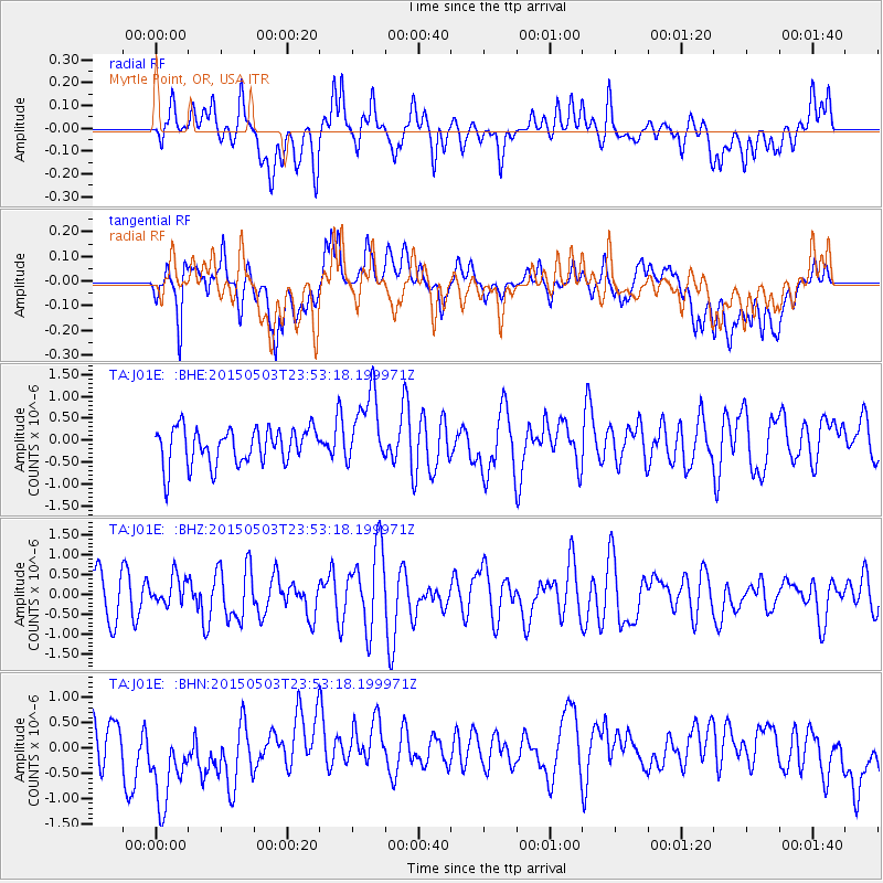
J01E Myrtle Point, OR, USA - Earthquake Result Viewer
*The percent match for this event was below the threshold and hence no stack was calculated.
| Earthquake location: |
New Britain Region, P.N.G. |
| Earthquake latitude/longitude: |
-5.5/151.9 |
| Earthquake time(UTC): |
2015/05/03 (123) 23:40:55 GMT |
| Earthquake Depth: |
35 km |
| Earthquake Magnitude: |
5.9 MWW, 5.7 MWB, 5.8 MWC |
| Earthquake Catalog/Contributor: |
NEIC PDE/NEIC COMCAT |
|
| Network: |
TA USArray Transportable Network (new EarthScope stations) |
| Station: |
J01E Myrtle Point, OR, USA |
| Lat/Lon: |
43.16 N/123.93 W |
| Elevation: |
128 m |
|
| Distance: |
89.5 deg |
| Az: |
46.714 deg |
| Baz: |
261.992 deg |
| Ray Param: |
$rayparam |
*The percent match for this event was below the threshold and hence was not used in the summary stack. |
|
| Radial Match: |
43.27162 % |
| Radial Bump: |
400 |
| Transverse Match: |
44.064587 % |
| Transverse Bump: |
400 |
| SOD ConfigId: |
7422571 |
| Insert Time: |
2019-04-18 15:47:21.131 +0000 |
| GWidth: |
2.5 |
| Max Bumps: |
400 |
| Tol: |
0.001 |
|
Signal To Noise
| Channel | StoN | STA | LTA |
| TA:J01E: :BHZ:20150503T23:53:18.199971Z | 0.68855524 | 3.627984E-7 | 5.26898E-7 |
| TA:J01E: :BHN:20150503T23:53:18.199971Z | 2.4056435 | 1.0326496E-6 | 4.2926132E-7 |
| TA:J01E: :BHE:20150503T23:53:18.199971Z | 2.0339992 | 8.512284E-7 | 4.1849987E-7 |
| Arrivals |
| Ps | |
| PpPs | |
| PsPs/PpSs | |


