You are here: Home > Network List > TA - USArray Transportable Network (new EarthScope stations) Stations List
> Station R53A Hurricane, WV, USA > Earthquake Result Viewer
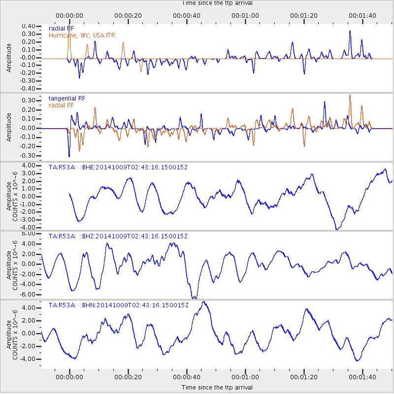
R53A Hurricane, WV, USA - Earthquake Result Viewer
*The percent match for this event was below the threshold and hence no stack was calculated.
| Earthquake location: |
Southern East Pacific Rise |
| Earthquake latitude/longitude: |
-32.1/-110.9 |
| Earthquake time(UTC): |
2014/10/09 (282) 02:32:05 GMT |
| Earthquake Depth: |
10 km |
| Earthquake Magnitude: |
6.6 MWW, 6.6 MWC |
| Earthquake Catalog/Contributor: |
NEIC PDE/NEIC COMCAT |
|
| Network: |
TA USArray Transportable Network (new EarthScope stations) |
| Station: |
R53A Hurricane, WV, USA |
| Lat/Lon: |
38.33 N/81.95 W |
| Elevation: |
294 m |
|
| Distance: |
75.1 deg |
| Az: |
23.192 deg |
| Baz: |
205.147 deg |
| Ray Param: |
$rayparam |
*The percent match for this event was below the threshold and hence was not used in the summary stack. |
|
| Radial Match: |
39.17849 % |
| Radial Bump: |
400 |
| Transverse Match: |
51.772896 % |
| Transverse Bump: |
312 |
| SOD ConfigId: |
803114 |
| Insert Time: |
2014-10-23 03:29:20.772 +0000 |
| GWidth: |
2.5 |
| Max Bumps: |
400 |
| Tol: |
0.001 |
|
Signal To Noise
| Channel | StoN | STA | LTA |
| TA:R53A: :BHZ:20141009T02:43:16.150015Z | 2.0618854 | 3.771239E-6 | 1.8290247E-6 |
| TA:R53A: :BHN:20141009T02:43:16.150015Z | 1.7024959 | 3.4368827E-6 | 2.018732E-6 |
| TA:R53A: :BHE:20141009T02:43:16.150015Z | 1.084265 | 1.6321811E-6 | 1.5053341E-6 |
| Arrivals |
| Ps | |
| PpPs | |
| PsPs/PpSs | |


