You are here: Home > Network List > TA - USArray Transportable Network (new EarthScope stations) Stations List
> Station W57A Gilead, NC, USA > Earthquake Result Viewer
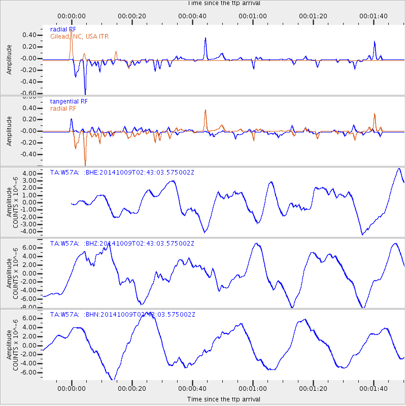
W57A Gilead, NC, USA - Earthquake Result Viewer
*The percent match for this event was below the threshold and hence no stack was calculated.
| Earthquake location: |
Southern East Pacific Rise |
| Earthquake latitude/longitude: |
-32.1/-110.9 |
| Earthquake time(UTC): |
2014/10/09 (282) 02:32:05 GMT |
| Earthquake Depth: |
10 km |
| Earthquake Magnitude: |
6.6 MWW, 6.6 MWC |
| Earthquake Catalog/Contributor: |
NEIC PDE/NEIC COMCAT |
|
| Network: |
TA USArray Transportable Network (new EarthScope stations) |
| Station: |
W57A Gilead, NC, USA |
| Lat/Lon: |
35.15 N/79.99 W |
| Elevation: |
85 m |
|
| Distance: |
72.9 deg |
| Az: |
26.114 deg |
| Baz: |
207.12 deg |
| Ray Param: |
$rayparam |
*The percent match for this event was below the threshold and hence was not used in the summary stack. |
|
| Radial Match: |
81.75793 % |
| Radial Bump: |
259 |
| Transverse Match: |
71.17725 % |
| Transverse Bump: |
400 |
| SOD ConfigId: |
803114 |
| Insert Time: |
2014-10-23 03:30:39.519 +0000 |
| GWidth: |
2.5 |
| Max Bumps: |
400 |
| Tol: |
0.001 |
|
Signal To Noise
| Channel | StoN | STA | LTA |
| TA:W57A: :BHZ:20141009T02:43:03.575002Z | 1.0632511 | 3.6934068E-6 | 3.473692E-6 |
| TA:W57A: :BHN:20141009T02:43:03.575002Z | 1.8645388 | 4.101745E-6 | 2.1998712E-6 |
| TA:W57A: :BHE:20141009T02:43:03.575002Z | 2.8868446 | 2.7510728E-6 | 9.529688E-7 |
| Arrivals |
| Ps | |
| PpPs | |
| PsPs/PpSs | |


