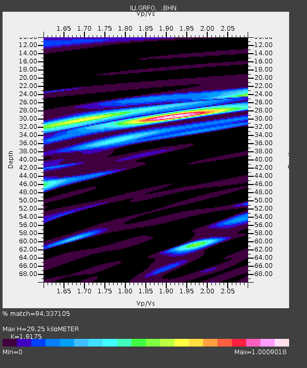
GRFO Grafenberg, Germany - Earthquake Result Viewer

Earthquake location: Near East Coast Of Honshu, Japan
Earthquake latitude/longitude: 40.2/142.2
Earthquake time(UTC): 1995/01/06 (006) 22:37:37 GMT
Earthquake Depth: 57 km
Earthquake Magnitude: 6.7 MB, 6.6 UNKNOWN, 7.0 MW
Earthquake Catalog/Contributor: WHDF/NEIC
Network: IU Global Seismograph Network (GSN - IRIS/USGS)
Station: GRFO Grafenberg, Germany
Lat/Lon: 49.69 N/11.22 E
Elevation: 425 m
Distance: 80.6 deg
Az: 330.225 deg
Baz: 35.836 deg
Ray Param: 0.048042323
Estimated Moho Depth: 29.25 km
Estimated Crust Vp/Vs: 1.92
Assumed Crust Vp: 6.182 km/s
Estimated Crust Vs: 3.224 km/s
Estimated Crust Poisson's Ratio: 0.31
Radial Match: 94.337105 %
Radial Bump: 360
Transverse Match: 81.86622 %
Transverse Bump: 359
SOD ConfigId: 6273
Insert Time: 2010-03-02 02:14:01.643 +0000
GWidth: 2.5
Max Bumps: 400
Tol: 0.001

Signal To Noise

ChannelStoNSTALTA
IU:GRFO: :BHN:19950106T22:49:13.452002Z9.9144053.2744604E-63.3027302E-7
IU:GRFO: :BHE:19950106T22:49:13.452002Z4.2146091.7691511E-64.1976637E-7
IU:GRFO: :BHZ:19950106T22:49:13.452002Z19.0249169.244986E-64.85941E-7
Arrivals
Ps4.4 SECOND
PpPs13 SECOND
PsPs/PpSs18 SECOND