You are here: Home > Network List > CI - Caltech Regional Seismic Network Stations List
> Station CWC CWC, Lone Pine, CA, USA > Earthquake Result Viewer
CWC CWC, Lone Pine, CA, USA - Earthquake Result Viewer

| Earthquake location: |
South Of Fiji Islands |
| Earthquake latitude/longitude: |
-22.1/-176.8 |
| Earthquake time(UTC): |
1997/10/14 (287) 09:53:18 GMT |
| Earthquake Depth: |
167 km |
| Earthquake Magnitude: |
6.7 MB, 7.7 UNKNOWN, 7.4 ME |
| Earthquake Catalog/Contributor: |
WHDF/NEIC |
|
| Network: |
CI Caltech Regional Seismic Network |
| Station: |
CWC CWC, Lone Pine, CA, USA |
| Lat/Lon: |
36.44 N/118.08 W |
| Elevation: |
1595 m |
|
| Distance: |
80.4 deg |
| Az: |
44.332 deg |
| Baz: |
233.484 deg |
| Ray Param: |
0.04792874 |
| Estimated Moho Depth: |
40.75 km |
| Estimated Crust Vp/Vs: |
1.60 |
| Assumed Crust Vp: |
6.291 km/s |
| Estimated Crust Vs: |
3.932 km/s |
| Estimated Crust Poisson's Ratio: |
0.18 |
|
| Radial Match: |
96.56897 % |
| Radial Bump: |
400 |
| Transverse Match: |
90.56603 % |
| Transverse Bump: |
400 |
| SOD ConfigId: |
3787 |
| Insert Time: |
2010-02-25 21:18:55.375 +0000 |
| GWidth: |
2.5 |
| Max Bumps: |
400 |
| Tol: |
0.001 |
|
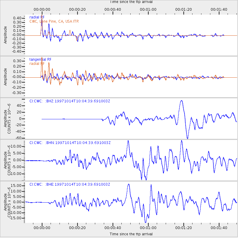
Signal To Noise
| Channel | StoN | STA | LTA |
| CI:CWC: :BHN:19971014T10:04:39.691003Z | 2.3801677 | 4.3402272E-7 | 1.8234962E-7 |
| CI:CWC: :BHE:19971014T10:04:39.691003Z | 1.3034947 | 3.5863232E-7 | 2.7513138E-7 |
| CI:CWC: :BHZ:19971014T10:04:39.691003Z | 9.7238865 | 1.4788077E-6 | 1.5207989E-7 |
| Arrivals |
| Ps | 4.0 SECOND |
| PpPs | 16 SECOND |
| PsPs/PpSs | 20 SECOND |


