You are here: Home > Network List > CI - Caltech Regional Seismic Network Stations List
> Station CWC CWC, Lone Pine, CA, USA > Earthquake Result Viewer
CWC CWC, Lone Pine, CA, USA - Earthquake Result Viewer
| Earthquake location: |
Northern Peru |
| Earthquake latitude/longitude: |
-4.4/-76.7 |
| Earthquake time(UTC): |
1997/10/28 (301) 06:15:17 GMT |
| Earthquake Depth: |
112 km |
| Earthquake Magnitude: |
6.6 MB, 6.3 MS, 7.2 UNKNOWN, 6.6 ME |
| Earthquake Catalog/Contributor: |
WHDF/NEIC |
|
| Network: |
CI Caltech Regional Seismic Network |
| Station: |
CWC CWC, Lone Pine, CA, USA |
| Lat/Lon: |
36.44 N/118.08 W |
| Elevation: |
1595 m |
|
| Distance: |
56.1 deg |
| Az: |
319.998 deg |
| Baz: |
127.356 deg |
| Ray Param: |
0.064048946 |
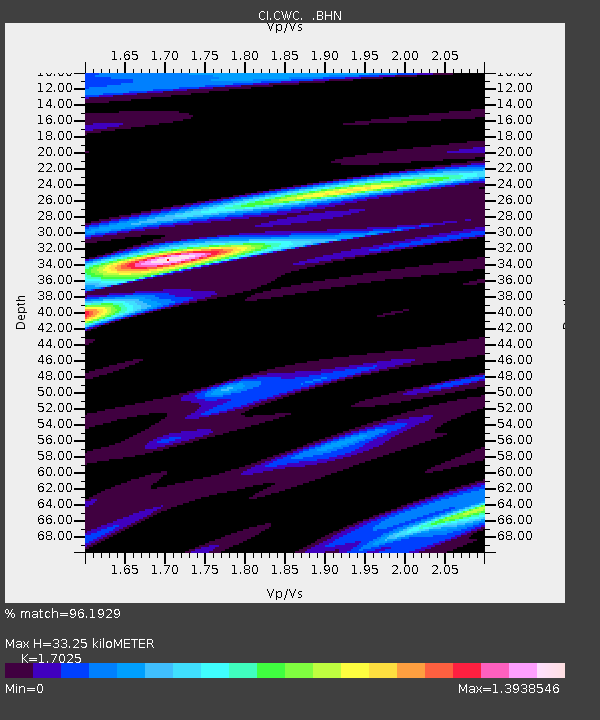
| Estimated Moho Depth: |
33.25 km |
| Estimated Crust Vp/Vs: |
1.70 |
| Assumed Crust Vp: |
6.291 km/s |
| Estimated Crust Vs: |
3.695 km/s |
| Estimated Crust Poisson's Ratio: |
0.24 |
|
| Radial Match: |
96.1929 % |
| Radial Bump: |
353 |
| Transverse Match: |
91.12142 % |
| Transverse Bump: |
400 |
| SOD ConfigId: |
3787 |
| Insert Time: |
2010-02-25 21:18:59.522 +0000 |
| GWidth: |
2.5 |
| Max Bumps: |
400 |
| Tol: |
0.001 |
|

Signal To Noise
| Channel | StoN | STA | LTA |
| CI:CWC: :BHN:19971028T06:24:13.977002Z | 4.213144 | 5.629917E-7 | 1.3362747E-7 |
| CI:CWC: :BHE:19971028T06:24:13.977002Z | 3.6612892 | 7.928099E-7 | 2.1653845E-7 |
| CI:CWC: :BHZ:19971028T06:24:13.977002Z | 13.009596 | 1.9921263E-6 | 1.5312744E-7 |
| Arrivals |
| Ps | 3.9 SECOND |
| PpPs | 14 SECOND |
| PsPs/PpSs | 17 SECOND |


